| Park Ranges | |
|---|---|
| Main Ranges | |
 | |
| Highest point | |
| Peak | Mount Robson, Rainbow Range |
| Elevation | 3,954 m (12,972 ft) [1] |
| Listing | Mountains of British Columbia |
| Coordinates | 53°06′38″N 119°09′23″W / 53.11056°N 119.15639°W [2] |
| Dimensions | |
| Area | 33,223 km2 (12,827 sq mi) |
| Geography | |
| Country | Canada |
| Provinces | British Columbia and Alberta |
| Range coordinates | 52°00′00″N 117°50′00″W / 52.00000°N 117.83333°W [3] |
| Parent range | Continental Ranges |
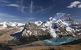
The Park Ranges, also known as the Main Ranges, are a group of mountain ranges in the Canadian Rockies of southeastern British Columbia and southwestern Alberta, Canada. It is one of the three main subranges and the most central of the Continental Ranges, extending from southeast of Mount McGregor to the Fernie Basin.
Subranges
- Blackwater Range
- Blue Range
- Bow Range
- Chaba Icefield
- Clemenceau-Chaba
- Columbia Icefield
- Drummond Group
- Freshfields
- Harrison Group
- Hooker Icefield
- Kitchen Range
- Le Grand Brazeau
- McKale-Chalco Divide
- Mitchell Range
- Morkill Ranges
- Ottertail Range
- Rainbow Range
- Royal Group
- Selwyn Range
- Spray Mountains
- Sundance Range
- The Ramparts
- Trident Range
- Van Horne Range
- Vermilion Range
- Wapta Icefield
- Waputik Icefield
- Waputik Mountains
- Winston Churchill Range
References
- ^ "Mount Robson Provincial Park". BC Parks. Government of British Columbia. Retrieved 2023-07-09.
- ^ "Mount Robson". Geographical Names Data Base. Natural Resources Canada. Retrieved 2023-07-09.
- ^ "Park Ranges". BC Geographical Names. Retrieved 2019-08-19.
- Park Ranges in the Canadian Mountain Encyclopedia
