| Continental Ranges | |
|---|---|
| Dimensions | |
| Area | 65,091 km2 (25,132 sq mi) |
| Geography | |
| Country | Canada |
| Provinces | British Columbia and Alberta |
| Range coordinates | 52°00′N 117°30′W / 52.000°N 117.500°W |
| Parent range | Canadian Rockies |
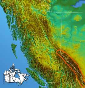
The Continental Ranges is a major grouping of mountain ranges in the Rocky Mountains located in eastern British Columbia and western Alberta. It is a physiographic designation for use by geologists and is not used by the general public; it is not recognized in Alberta, and does not appear on topographic maps, [1] although the names of its subranges (the Kootenay, Park or Main Ranges, and Front Ranges) are in common use. It is the largest and best-known of the three main such subdivisions of the Canadian Rockies, the others being the Hart Ranges and the Muskwa Ranges. [2]
Sub-ranges
There are three main subdivisions of the Continental Ranges: the Front Ranges, the Park Ranges, and the Kootenay Ranges. Each of those three subdivisions is further divided into individual ranges as follows:
- Front Ranges
- Bare Range
- Bighorn Range
- Bosche Range
- De Smet Range
- Elk Range
- Fairholme Range
- First Range
- Fisher Range
- Goat Range
- Greenhills Range
- High Rock Range
- Highwood Range
- Jacques Range
- Kananaskis Range
- Lizard Range
- Maligne Range
- Miette Range
- Murchison Group
- Nikanassin Range
- Opal Range
- Palliser Range
- Queen Elizabeth Ranges
- Ram Range
- Sawback Range
- Slate Range
- Taylor Range
- Vermilion Range
- Victoria Cross Ranges
- Whitegoat Peaks
- Wisukitsak Range
- Park Ranges, also known as the Main Ranges.
- Blackwater Range
- Blue Range
- Bow Range
- Chaba Icefield
- Clemenceau-Chaba
- Columbia Icefield
- Drummond Group
- Freshfields
- Harrison Group
- Hooker Icefield
- Kitchen Range
- Le Grand Brazeau
- McKale-Chalco Divide
- Mitchell Range
- Morkill Ranges
- Ottertail Range
- Rainbow Range
- Royal Group
- Selwyn Range
- Spray Mountains
- Sundance Range
- The Ramparts
- Trident Range
- Van Horne Range
- Vermilion Range
- Wapta Icefield
- Waputik Icefield
- Waputik Mountains
- Winston Churchill Range
- Kootenay Ranges
References
- ^ "Continental Ranges". BC Geographical Names.
- ^ Landforms of British Columbia Archived 2016-03-04 at the Wayback Machine, S Holland, Govt of BC Bulletin No. 58, 1976
