This article needs additional citations for
verification. (December 2010) |
Old Bridge | |
|---|---|
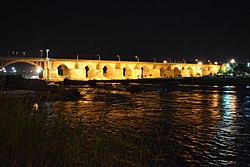
 Old Bridge of Dezful in Night | |
| Coordinates | 32°22′54″N 48°23′27″E / 32.3816°N 48.3908°E |
| Crosses | Dez River |
| Locale | Dezful, Iran |
| Official name | Sasanid Bridge |
| Heritage status | Listed as national cultural heritage since 1932 with NO. 84 |
| Characteristics | |
| Design | Roman arch bridge |
| Material | Stone |
| Total length | 385.5 m (1,265 ft) |
| Width | 9.5 m (31 ft) |
| Height | 15 m (49 ft) |
| No. of spans | 14 |
| History | |
| Construction start | 260 AD |
| Construction end | 260 AD |
| Location | |
|
| |
The Old Bridge of Dezful is located near the city of Dezful in South Western Iran. This bridge connects the western and eastern part of the city of Dezful.
History
The design of the bridge in its current state is 1700 years old and goes back to the Sassanid dynasty, however the original foundation of the bridge was built during the Elamite era. [1]
Gallery
-
Bridge of Dezful - 1870s
-
The Old Bridge of Dezful


