From Wikipedia, the free encyclopedia
Location of Greenup County in Kentucky
This is a list of the National Register of Historic Places listings in Greenup County, Kentucky .
This is intended to be a complete list of the properties and districts on the
National Register of Historic Places in
Greenup County ,
Kentucky ,
United States . The locations of National Register properties and districts for which the latitude and longitude coordinates are included below, may be seen in a map.
[1]
There are 20 properties and districts listed on the National Register in the county.
This
National Park Service list is complete through
NPS recent listings posted May 10, 2024.
[2]
Contents: Counties in Kentucky
Current listings
[3]
Name on the Register
Image
Date listed
[4]
Location
City or town
Description
1
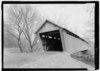
Bennett's Mill Covered Bridge
Bennett's Mill Covered Bridge
March 26, 1976 (
#76000892 )
Kentucky Route 2125 west of Greenup
38°37′50″N 82°55′37″W / 38.630556°N 82.926944°W / 38.630556; -82.926944 (Bennett's Mill Covered Bridge )
Greenup
2
Front Street District
Front Street District
January 27, 1988 (
#87002448 ) Front St.
38°34′39″N 82°50′03″W / 38.577500°N 82.834167°W / 38.577500; -82.834167 (Front Street District )
Greenup
3
General U.S. Grant Bridge
General U.S. Grant Bridge
May 31, 2001 (
#01000560 )
Ohio River -Chillicothe and 2nd St.
38°43′29″N 82°59′53″W / 38.724722°N 82.998056°W / 38.724722; -82.998056 (General U.S. Grant Bridge )
South Portsmouth
Extends into
Scioto County, Ohio . Demolished in 2001.
4
Greenup Masonic Lodge
Greenup Masonic Lodge
January 27, 1988 (
#87002447 ) 314 Main St.
38°34′40″N 82°50′12″W / 38.577778°N 82.836667°W / 38.577778; -82.836667 (Greenup Masonic Lodge )
Greenup
5
Kouns-Hoffman House
Kouns-Hoffman House
January 27, 1988 (
#87002445 ) 208 Jefferson St.
38°34′37″N 82°50′00″W / 38.576806°N 82.833333°W / 38.576806; -82.833333 (Kouns-Hoffman House )
Greenup
6
KY 2541 Bridge
KY 2541 Bridge
January 27, 1988 (
#87002446 ) Main St. over the
Little Sandy River
38°34′50″N 82°50′25″W / 38.580556°N 82.840278°W / 38.580556; -82.840278 (KY 2541 Bridge )
Greenup
7
Lower Shawneetown
Lower Shawneetown
April 28, 1983 (
#83002784 ) Northwest of
Kentucky Route 8
[5]
38°42′54″N 83°01′42″W / 38.715000°N 83.028333°W / 38.715000; -83.028333 (Lower Shawneetown )
South Portsmouth
8
Lower Shawneetown Archeological District
Lower Shawneetown Archeological District
November 29, 1985 (
#85003334 ) Scattered around South Portsmouth
[6]
38°42′58″N 83°01′21″W / 38.716111°N 83.022500°W / 38.716111; -83.022500 (Lower Shawneetown Archeological District )
South Portsmouth
Includes Lower Shawneetown and Group A of the Portsmouth Earthworks,
[7] and extends into
Lewis County
9
McConnell House, Law Office, and Slave Quarters
McConnell House, Law Office, and Slave Quarters
July 30, 1975 (
#75000764 ) West of Wurtland on
U.S. Route 23
38°33′07″N 82°47′19″W / 38.551944°N 82.788611°W / 38.551944; -82.788611 (McConnell House, Law Office, and Slave Quarters )
Wurtland
10
McKee House
McKee House
January 27, 1988 (
#87002439 ) 1023 Riverside Dr.
38°34′28″N 82°49′47″W / 38.574444°N 82.829861°W / 38.574444; -82.829861 (McKee House )
Greenup
11
Methodist Episcopal Church South
Methodist Episcopal Church South
January 27, 1988 (
#87002444 ) Main St.
38°34′36″N 82°50′05″W / 38.576667°N 82.834722°W / 38.576667; -82.834722 (Methodist Episcopal Church South )
Greenup
12
Oldtown Covered Bridge
Oldtown Covered Bridge
March 26, 1976 (
#76000893 ) South of Oldtown off
Kentucky Route 1
38°25′53″N 82°53′42″W / 38.431389°N 82.895°W / 38.431389; -82.895 (Oldtown Covered Bridge )
Oldtown
13
Portsmouth Earthworks, Group A
Portsmouth Earthworks, Group A
December 4, 1980 (
#80001534 ) Between County Route 8 and the
Ohio River , west of South Portsmouth
[8]
38°43′18″N 83°01′23″W / 38.7216°N 83.023°W / 38.7216; -83.023 (Portsmouth Earthworks, Group A )
South Portsmouth
14
Russell Railroad YMCA
Russell Railroad YMCA
May 2, 2001 (
#01000452 ) 451 Verhon St.
38°32′02″N 82°41′52″W / 38.533889°N 82.697778°W / 38.533889; -82.697778 (Russell Railroad YMCA )
Russell
15
South Greenup District
South Greenup District
January 27, 1988 (
#87002443 ) Roughly bounded by the
C&O railroad line, Laurel St., Seaton Ave., and Washington St.
38°34′37″N 82°50′19″W / 38.576944°N 82.838611°W / 38.576944; -82.838611 (South Greenup District )
Greenup
16
Jesse Stuart House
Jesse Stuart House
June 1, 1982 (
#82002700 ) Stuarts Lane off W. Hollow Rd.
38°33′02″N 82°50′13″W / 38.550556°N 82.836944°W / 38.550556; -82.836944 (Jesse Stuart House )
Greenup
17
Warnock House
Warnock House
January 27, 1988 (
#87002442 ) 404 Harrison
38°34′38″N 82°50′14″W / 38.577222°N 82.837361°W / 38.577222; -82.837361 (Warnock House )
Greenup
18
West Main Street District
West Main Street District
January 27, 1988 (
#87002441 ) W. Main St.
38°34′44″N 82°50′18″W / 38.578889°N 82.838333°W / 38.578889; -82.838333 (West Main Street District )
Greenup
19
Worthington House
Worthington House
January 27, 1988 (
#87002438 )
U.S. Route 23 at Academy Rd.
38°34′06″N 82°49′56″W / 38.568333°N 82.832222°W / 38.568333; -82.832222 (Worthington House )
Greenup
20
Wurtland Union Church
Wurtland Union Church
December 4, 2008 (
#08001119 ) 325 Wurtland Ave.
38°33′02″N 82°46′52″W / 38.550556°N 82.781111°W / 38.550556; -82.781111 (Wurtland Union Church )
Wurtland
See also References
^ The latitude and longitude information provided in this table was derived originally from the National Register Information System, which has been found to be fairly accurate for about 99% of listings. Some locations in this table may have been corrected to current GPS standards.
^ National Park Service,
United States Department of the Interior ,
"National Register of Historic Places: Weekly List Actions" , retrieved May 10, 2024.
^ Numbers represent an alphabetical ordering by significant words. Various colorings, defined
here , differentiate
National Historic Landmarks and
historic districts from other NRHP buildings, structures, sites or objects.
^ The eight-digit number below each date is the number assigned to each location in the
National Register Information System database, which can be viewed by clicking the number.
^ Location derived from
this historical marker ; the NRIS lists the site as "Address Restricted"
^ Location derived from those of other Portsmouth sites included in the district; NRIS mentions them but lists this site as "Address Restricted".
^
"National Register Information System" .
National Register of Historic Places .
National Park Service . June 30, 2007.
^ Location derived from
this map; the NRIS lists the site as "Address Restricted"
Topics Lists by state Lists by insular areas Lists by associated state Other areas Related


