-
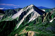 Mount Washiba seen from Suisho Mountain Villa
 -
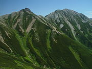 Mount Washiba seen from Mount Jii
 -
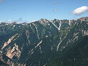 Mount Washiba seen from Tsubakuro Mountain Villa
 -
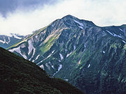
 Mount Washiba seen from Mount daitenjo
 -
 Mount Washiba seen from Sugoroku Mountain Villa
| Mount Washiba | |
|---|---|
| 鷲羽岳 | |
 Mount Washiba seen from Mount Mitsumatarenge | |
| Highest point | |
| Elevation | 2,924 m (9,593 ft) [1] |
| Listing |
List of mountains in Japan 100 Famous Japanese Mountains |
| Coordinates | 36°25′35″N 137°36′10″E / 36.42639°N 137.60278°E |
| Naming | |
| English translation | Eagle wing Mountain |
| Language of name | Japanese |
| Geography | |
 Mount Washiba Location in Japan | |
| Location | Toyama Prefecture, Nagano Prefecture, Japan |
| Parent range | Hida Mountains |
| Geology | |
| Mountain type | Stratovolcanoes, shield volcanoes, lava domes |
| Last eruption | 12,000 years ago |
Mount Washiba (鷲羽岳, Washiba-dake) is a peak and complex of volcanoes in the Hida Mountains range of the Japanese Alps at 2924m, located in Nagano Prefecture and Toyama Prefecture, central Honshu, Japan. It is listed in 100 Famous Japanese Mountains. [2]
Geography
Mount Washiba is the 29th-tallest mountain in Japan.
Gallery


References
- ^ "日本の主な山岳標高(富山県の山)". 国土地理院. Retrieved 2010-01-05.
- ^ 『日本百名山』 深田久弥(著)、 朝日新聞社、1982年、 ISBN 4-02-260871-4, pp. 202-205
See also
| Hokkaidō | |||||||||
|---|---|---|---|---|---|---|---|---|---|
|
Tōhoku region Jōshinetsu region |
| ||||||||
| Kantō region | |||||||||
| Chūbu region |
| ||||||||
| Western Japan | |||||||||
| |||||||||