| Mount Amagi | |
|---|---|
| 天城山 | |
 View from the north | |
| Highest point | |
| Elevation | 1,406 m (4,613 ft) [1] [2] |
| Listing | Mountains of Japan |
| Coordinates | 34°51′46″N 139°00′06″E / 34.8628°N 139.0017°E [2] [1] |
| Geography | |
 Mount Amagi | |
| Country | Japan |
| Prefecture | Shizuoka |
| Peninsula | Izu |
| Geology | |
| Mountain type | Stratovolcano |
| Type of rock | Andesite [1] |
| Volcanic arc/ belt | Izu–Bonin–Mariana Arc |
| Last eruption | 0.2 Ma [1] |
| Climbing | |
| Easiest route | Hike |
Mount Amagi (天城山, Amagi-san) is a range of volcanic mountains in central Izu Peninsula in Shizuoka Prefecture, Japan, forming the border between Izu City and Higashi-Izu Town. It is also referred to as the Amagi Mountain Range (天城連山, Amagi Renzan).

The Amagi mountains have several peaks, the tallest of which are Bansaburōdake (万三郎岳) at 1,406 metres (4,613 ft), Banjirōdake (万二郎岳) at 1,300 metres (4,300 ft), and Tōgasayama (遠笠山) at 1,197 metres (3,927 ft). [3]
There are several hiking routes to the top. Flora in the area include rhododendrons, Japanese andromeda, stewartia monadelpha and Siebold's beech.
Many ships of the Imperial Japanese Navy were named after it, including a corvette, a battlecruiser and an aircraft carrier.
Amagi is listed as one of the 100 Famous Japanese Mountains in a book composed in 1964 by mountaineer/ author Kyūya Fukada. [4]
Gallery
-
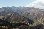
 View from the north
 -
 View from the south
 -
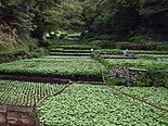 Mount Amagi is a well-known producer of wasabi.


References
- ^ a b c d "Amagi San". Geological Survey of Japan. Retrieved 2023-04-01.
- ^ a b "Topographic map of Mount Amagi". opentopomap.org. Retrieved 2023-05-28.
- ^ "Amagi-san". Peakbagger.com. Retrieved 2023-04-01.
- ^ Hyakumeizan, Hiking Japan! Archived 2007-01-09 at the Wayback Machine. Japan Gazetteer.
External links
- Amagi San - Geological Survey of Japan
- Tourist brochure - Izu city official
- Hiking Map - Izu city official (in Japanese) (web.archive.org)
| Hokkaidō | |||||||||
|---|---|---|---|---|---|---|---|---|---|
|
Tōhoku region Jōshinetsu region |
| ||||||||
| Kantō region | |||||||||
| Chūbu region |
| ||||||||
| Western Japan | |||||||||
| |||||||||
|
| This Shizuoka Prefecture location article is a stub. You can help Wikipedia by expanding it. |