Mount Pleasant | |
 Mount Pleasant | |
| Location | 15 Bracebridge Rd., Newton, Massachusetts |
|---|---|
| Coordinates | 42°19′53″N 71°12′8″W / 42.33139°N 71.20222°W |
| Built | 1856 |
| Architectural style | Italianate |
| MPS | Newton MRA |
| NRHP reference No. | 86001851 [1] |
| Added to NRHP | September 04, 1986 |
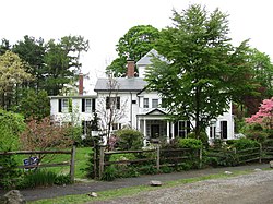
Mount Pleasant is a historic two-story wood frame estate house in Newton Centre, Massachusetts, built circa 1856. It is a well-preserved example of the academic Italianate style of architecture, with a three-bay facade and hip roof with a small gable over the centered entry, and a three-story turret. [2] The house was listed on the National Register of Historic Places in 1986. [1]
The Mount Pleasant house was built for Roswell Turner, a major land owner and real estate developer in the Newton Centre area. The house and surrounding property were owned for many of the later years of the 19th century and early years of the 20th century by Charles S. Davis, another major force in the development of Newton Centre. [2] Under Davis's ownership, much of the original estate was split off for other houses and streets to be built, [3] [4] while the original Mount Pleasant house remained. By 1917, Mr. Addison C. Burnham owned the house and was calling his smaller property "Jolly's Hollow". [5] [6] [7] [8] [9] Subsequent owners continued to call it "Jolly's Hollow", at least into 2018. [10]
In January 1997, the Wilson family, owners of Jolly's Hollow/Mount Pleasant, donated 0.5 acres of the wooded portion of their property to the City of Newton for the creation of the Wilson Conservation Area. In 2012, the Wilsons donated to the Newton Conservators a conservation restriction to preserve an additional 1.5 acres of their land. [11] [12] [13] This conservation land, as intended, adds a link to a popular walking trail that connects a playground, elementary school, and park nearby, and also to suburbs to the west. The walking trail is on top of the underground Cochituate and Sudbury Aqueducts (built in 1848 and 1878, respectively, to supply water to Boston and nearby municipalities). [10] The Mount Pleasant house happens to be situated right between the two aqueducts, which both have easements under the Jolly's Hollow property. [5]
The Wilsons sold the house and property in July 2018 to the Fiete family, having originally purchased it from the Scribner family in March 1966. [14] [15]
See also
References
- ^ a b "National Register Information System". National Register of Historic Places. National Park Service. April 15, 2008.
- ^ a b "NRHP nomination for Mount Pleasant". Commonwealth of Massachusetts. Retrieved 8 June 2020.
- ^ Atlas of the City of Newton, Massachusetts. G.M. Hopkins & Co. 1874. p. U. Retrieved 8 June 2020.
- ^ Bromley, George W. and Walter S. (1907). Atlas of the City of Newton, Massachusetts. G.W. Bromley and Co. p. 18. Retrieved 8 June 2020.
- ^ a b "Newton 1917 [map]". City of Newton, Massachusetts, copied from G.W. Bromley Atlas of Newton. 1917. Retrieved 8 June 2020.
- ^ Gardner, Lester D. (1922). Who's Who in American Aeronautics. The Gardner, Moffat Company (New York). p. 31. Retrieved 8 June 2020.
- ^ "Newton Centre". The Newton Graphic. 2 May 1919. p. 4. Retrieved 8 June 2020.
- ^ "Newton Centre". The Newton Graphic. 6 June 1919. Retrieved 8 June 2020.
- ^ "Newton Centre". The Newton Graphic. 2 June 1922. p. 5. Retrieved 8 June 2020.
- ^ a b Luria, Sarah (27 November 2017). "The Story of Jolly's Hollow: How Conservation Land Builds Community" (PDF). Newton Conservators, and Newton Tab. Retrieved 8 June 2020.
- ^ "Wilson Conservation Area". City of Newton Conservation Commission. Archived from the original on 2018-09-28. Retrieved 19 December 2016.
- ^ "Wilson Conservation Lands". Newton Conservators. 2018. Retrieved 2022-01-07.
- ^ "Wilson". City of Newton. Retrieved 2022-01-07.
- ^ "15 Bracebridge Rd, Newton, MA 02459, Status: Sold". Redfin. 2018. Retrieved 8 June 2020.
- ^ "Southern Middlesex Recorded/Registered Land: Wilson, Richard". Commonwealth of Massachusetts. July 26, 2018. Retrieved 6 January 2019.


