| McGinnis Mountain | |
|---|---|
 McGinnis Mountain summit | |
| Highest point | |
| Elevation | 4,232 ft (1,290 m) [1] |
| Prominence | 656 ft (200 m) [2] |
| Parent peak | Stroller White Mountain [3] |
| Coordinates | 58°27′07″N 134°35′54″W / 58.45194°N 134.59833°W [3] |
| Geography | |
 McGinnis Mountain Location of McGinnis Mountain in Alaska | |
| Location |
Tongass National Forest Juneau Borough Alaska, United States |
| Parent range |
Coast Mountains Boundary Ranges Juneau Icefield [3] |
| Topo map | USGS Juneau B-2 |
McGinnis Mountain, also known as Mount McGinnis, is a 4,232-foot (1,290 m) mountain summit located in the Boundary Ranges, in the U.S. state of Alaska. [4] The peak is situated near the toe of the Mendenhall Glacier, within Tongass National Forest, 11 mi (18 km) north-northwest of Juneau, Alaska, and 6 mi (10 km) north of Juneau International Airport. Although modest in elevation, relief is significant since the mountain rises up from sea level at Auke Bay in less than five miles. McGinnis Mountain is often seen and photographed with Stroller White Mountain, a 5,118-foot (1,560 m) summit 1.6 mi (3 km) to the north because they are together in the background behind Mendenhall Lake, a popular tourist and recreation area.
History
The mountain's name was officially adopted in 1930 by the United States Geological Survey [4] McGinnis Mountain takes its name from McGinnis Creek, which drains its northern slopes. McGinnis Creek in turn was originally named McInnis River in 1891 by John McInnis and Edward Brennan who had staked claims in the area. In 1903, the name was reported as McGinnis Creek by the USGS. [5] [6]
Climate
Based on the Köppen climate classification, McGinnis Mountain is located in a subarctic climate zone with cold, snowy winters, and mild summers. [7] Temperatures can drop below −20 °C with wind chill factors below −30 °C. This climate supports the Mendenhall Glacier and Juneau Icefield to the mountain's east. May and June are the best months for climbing in terms of catching favorable weather.
See also
References
- ^ McGinnis Mountain, listsofjohn.com
- ^ McGinnis Mountain, listsofjohn.com
- ^ a b c "McGinnis Mountain, Alaska". Peakbagger.com. Retrieved 2019-06-10.
- ^ a b "McGinnis Mountain". Geographic Names Information System. United States Geological Survey, United States Department of the Interior. Retrieved 2019-06-10.
- ^ Dictionary of Alaska Place Names, Donald J. Orth author, United States Government Printing Office (1967), page 609
- ^ "McGinnis Creek". Geographic Names Information System. United States Geological Survey, United States Department of the Interior. Retrieved 2019-06-10.
- ^ Peel, M. C.; Finlayson, B. L.; McMahon, T. A. (2007). "Updated world map of the Köppen−Geiger climate classification". Hydrol. Earth Syst. Sci. 11. ISSN 1027-5606.
Gallery
-
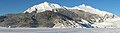 McGinnis Mountain and Stroller White Mountain (right) in winter
 -
 McGinnis centered, seen with Stroller White, Mendenhall Glacier, and Nugget Falls from the Mendenhall Glacier Visitor Center
 -
 McGinnis (left), Mendenhall Towers, and Mt. Wrather reflected in Auke Lake
 -
 McGinnis and Stroller White reflected in Mendenhall Lake


External links
- Weather forecast: McGinnis Mountain