From Wikipedia, the free encyclopedia
Provincial park in Ontario, Canada
| Mara Provincial Park | |
|---|---|
IUCN category II (
national park) | |
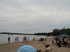
 View of the beach area along Lake Simcoe at the Park. | |
| Location | Ontario, Canada |
| Nearest city | Orillia, Ontario |
| Coordinates | 44°35′13″N 79°21′36″W / 44.587°N 79.360°W / 44.587; -79.360 |
| Area | 40 ha (99 acres) |
| Established | 1970 [1] |
| Governing body | Ontario Parks |
Mara Provincial Park is a provincial park in Ramara, Ontario, Canada. It is situated on the northern shore of Lake Simcoe, and provides camping, boating, swimming and other recreational activities.
References
- ^ "Mara Provincial Park - Recreation". Protected Planet. Archived from the original on 26 August 2014.
External links
Wikimedia Commons has media related to
Mara Provincial Park.
| International | |
|---|---|
| National | |
|
| This Canadian protected area related article is a stub. You can help Wikipedia by expanding it. |

