| Llanwrin | |
|---|---|
 Llanwrin in 2006 | |
 Llanwrin Location within
Powys | |
| OS grid reference | SH787034 |
| Principal area | |
| Preserved county | |
| Country | Wales |
| Sovereign state | United Kingdom |
| Post town | MACHYNLLETH |
| Postcode district | SY20 |
| Dialling code | 01650 |
| Police | Dyfed-Powys |
| Fire | Mid and West Wales |
| Ambulance | Welsh |
| UK Parliament | |
Llanwrin ( ⓘ) is a small village in the valley of the Afon Dyfi in Powys, Wales, about two miles north-east of Machynlleth.
History and background
Historically, it was in the county of Montgomeryshire ( Welsh: Sir Drefaldwyn).
The village is named after its church, dedicated to St. Gwrin, which dates from late medieval times and was last restored in 1864. [1] The nearby historically significant house of Mathafarn dates back to at least 1485.
Once a thriving community with its own blacksmith, pub and village shop – all long since closed – in recent years the village has been a collection of houses stretched along the B4404 road.
Straw man
Llanwrin is known locally for its various straw man characters, which are located from time to time on the small triangle-shaped village green.
-
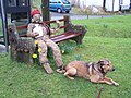 The Strawman
 -
 Church of St Ust and St Dyfrig


References
External links
- Photos of Llanwrin and surrounding area on geograph
- Eco Dyfi Valley Partnership
- Genealogical information about Llanwrin
- Map of Llanwrin in 1837

|
| This Powys location article is a stub. You can help Wikipedia by expanding it. |