Labastide-Saint-Sernin | |
|---|---|
 The church in Labastide-Saint-Sernin | |
.svg) Coat of arms | |
 Labastide-Saint-Sernin  Labastide-Saint-Sernin | |
| Coordinates: 43°44′23″N 1°28′19″E / 43.7397°N 1.4719°E | |
| Country | France |
| Region | Occitania |
| Department | Haute-Garonne |
| Arrondissement | Toulouse |
| Canton | Pechbonnieu |
| Government | |
| • Mayor (2020–2026) | Bertrand Sarrau [1] |
| Area 1 | 4.97 km2 (1.92 sq mi) |
| Population (2021)
[2] | 1,950 |
| • Density | 390/km2 (1,000/sq mi) |
| Time zone | UTC+01:00 ( CET) |
| • Summer ( DST) | UTC+02:00 ( CEST) |
| INSEE/Postal code |
31252 /31620 |
| Elevation | 126–184 m (413–604 ft) (avg. 130 m or 430 ft) |
| 1 French Land Register data, which excludes lakes, ponds, glaciers > 1 km2 (0.386 sq mi or 247 acres) and river estuaries. | |
Labastide-Saint-Sernin (French pronunciation: [labastid sɛ̃ sɛʁnɛ̃]; Occitan: La Bastida de Sant Sarnin) is a commune in the Haute-Garonne department in southwestern France.
Population
| Year | Pop. | ±% |
|---|---|---|
| 1962 | 181 | — |
| 1968 | 380 | +109.9% |
| 1975 | 603 | +58.7% |
| 1982 | 980 | +62.5% |
| 1990 | 1,208 | +23.3% |
| 1999 | 1,329 | +10.0% |
| 2006 | 1,685 | +26.8% |
| 2008 | 1,756 | +4.2% |
| 2011 | 1,820 | +3.6% |
| 2015 | 1,876 | +3.1% |
| 2016 | 1,899 | +1.2% |
| 2018 | 1,918 | +1.0% |
The inhabitants of the commune are known as Labastidiens and Labastidiennes.
Sights
-
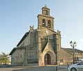 Church
 -
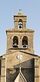 Bell gables
 -
 Town Hall


See also
References
- ^ "Répertoire national des élus: les maires" (in French). data.gouv.fr, Plateforme ouverte des données publiques françaises. 13 September 2022.
- ^ "Populations légales 2021". The National Institute of Statistics and Economic Studies. 28 December 2023.
Wikimedia Commons has media related to
Labastide-Saint-Sernin.
| Authority control databases: National |
|---|
|
| This Haute-Garonne geographical article is a stub. You can help Wikipedia by expanding it. |