Kuala Belait | |
|---|---|
Municipal area and town | |
.jpg)   .jpg) Clockwise from top left: Kuala Belait at night, Belait Beach, Belait River, Marine Construction Yard | |
 Location in Brunei | |
| Coordinates: 4°34′58″N 114°11′30″E / 4.582835°N 114.191783°E | |
| Country | Brunei |
| District | Belait |
| Mukim | Kuala Belait |
| Government | |
| • Village head | Sufrizal Hamdan [1] |
| Population (2016)
[2] | |
| • Total | 4,259 |
| Time zone | UTC+8 ( BNT) |
| Postcode | KA1131 |
| Website |
bandaran-kb |
Kuala Belait ( Malay: Pekan Kuala Belait; Jawi: کوالا بلايت; abbrev: KB) is the administrative town of Belait District, Brunei. [3] [4] The population of the town proper was 4,259 in 2016. [2] Kuala Belait is officially a municipal area (kawasan bandaran), [5] as well as a village under the mukim of the same name. [6] The town is located 85 kilometres (53 mi) west of the country's capital Bandar Seri Begawan, [4] and 20 kilometres (12 mi) west of Seria, the district's other town. [7] It is also in the westernmost part of country, near the mouth of the Belait River. [8]
History
In 1914, a 60 miles (97 km) road connecting Kuala Belait and Brunei Town was completed. [9] Kuala Belait was a small fishing village at the turn of the 20th century. [10] The natives were Belait Malays who were mainly fishermen. [11] There was a disagreement between the two groups of settlers which caused one of those groups to the relocated up to the west bank of the mouth of the Belait River. [11] The village is now known as Sungai Teraban. [11]

The Kuala Belait Sanitary Board was established in 1929, and this marked the transition of Kuala Belait from a village to a town. [12] In 1930, British Malayan Petroleum Company (BMPC) constructed a telephone line along the Belait coastline which linked up Seria and Rasau with their main headquarters in Kuala Belait. [13] A hospital was built by BMPC and completed in 1931, [12] followed by the first private English school being built that same year. [14] Telephone lines stretching from Kuala Belait to Tutong was dismantled in 1934 after failing to meet expectations. [15] By 1939, pipelines and roads between the town and Miri has been constructed. [16]
On December 16, 1941, the town was captured after an amphibious assault was carried out at Belait Beach by 10,000 soldiers from the Japanese Kawaguchi Detachment and remained part of the Japanese occupation of British Borneo during World War II. [17] [18] Moreover during the Japanese occupation of Kuala Belait, war crimes such as massacre and execution of Indian prisoners of war (POW) of the 2/15th Punjab Regiment were committed out by the Japanese. [19] [20] [21] It can also be noted that 55 Indian prisoners died from starvation in the POW camp in town. [22] As part of Operation Oboe Six, the Australian 9th Division arrived in Kuala Belait on June 24, 1945, [23] followed by the recapturing of the port of Kuala Belait. [24] Reconstruction plans for the destroyed town were approved in 1949. [25] [26] Within the same year, a new church in town was consecrated. [27]
Due to the increase in profits from the oil industry in the 1950s and 1960s, rapid development was seen throughout Kuala Belait. [28] The first offshore gas field, South West Ampa, [29] was discovered 13 kilometres (8.1 mi) off Kuala Belait in 1963. [30] During the 1962 Brunei revolt, rebels of the TKNU managed to gain control of the town, [31] but was soon liberated by the 1/2nd Battalion Gurkha Rifles Regiment. [32] Siege by the rebels against the town's police station were repelled by the local police force. [33] After independence from Britain in 1984, a number of new government buildings were constructed to house the local services of the Brunei government. In 1990s, the two-lane road along the coast leading from Muara to Kuala Belait was upgraded to 4-lane. [34]
Governance

Administrative division
The area of Kuala Belait comprises territorial division which can be informally grouped into three main areas: Pekan Kuala Belait or Kuala Belait Town, and Kampong Pandan and Mumong suburbs. The latter two areas are further divided into three and two kampongs or villages respectively. Pekan Kuala Belait is also officially a kampong-level administrative division. All of the villages constitute almost all of Mukim Kuala Belait, a subdistrict of Belait. [35]
| Main area | Kampong |
|---|---|
| Kuala Belait Town | Pekan Kuala Belait |
| Kampong Pandan | Kampong Pandan 'A' |
| Kampong Pandan 'B' | |
| Kampong Pandan 'C' | |
| Mumong | Kampong Mumong 'A' |
| Kampong Mumong 'B' |
Local authority and town definition
The town of Kuala Belait is administered under Jabatan Bandaran Kuala Belait dan Seria (Kuala Belait and Seria Municipal Department), a government department under Kementerian Hal Ehwal Dalam Negeri (the Ministry of Home Affairs). [36] The department comprises Lembaga Bandaran or the Municipal Board, which is headed by Pengerusi Lembaga Bandaran (Chairman of the Municipal Board). The current chairman is Ridzuan Haji Ahmad. [37]
Overlapping territory
The area under the authority of the Municipal Department overlaps with that under Jabatan Daerah Belait or the Belait District Office. The municipal area consists of Pekan Kuala Belait, the whole of Kampong Pandan suburb, and parts of Mumong suburb. However, all of the kampongs are also under the governance of the Belait District Office, since they constitute the proper subdivisions of the district and subdistricts, and subsequently the headmen of the kampongs, known as ketua kampong (with the exception of Pekan Kuala Belait since there is none assigned), answers to the Pegawai Daerah or District Officer.
Economy

Oil and gas
Kuala Belait is located in the vicinity of the onshore Rasau gas field. [38] However Brunei Shell has various facilities in town to support the oil and gas production facilities in the vicinity.
The Kuala Belait Bunkering Station (KBBS) is located near the mouth of the Belait River. [39] It supplies domestic gas to the town and other bulk chemicals in support of the various activities. [39] The Kuala Belait Wharf is the main point from which personnel to and from the offshore platforms, off the Belait districts, embark and disembark. [39]
Marine
The Kuala Belait supply base is located to the south of the wharf, and is the main point for logistics for Shell. [40] The Marine Construction Yard (MCY) in Sungai Duhon, commonly known as SCO, is where construction of marine structures are carried out prior to installation offshore. [41]
Demography
Kampong Kuala Balai has historically served as the Belait population's hub. However, the population has scattered over the past 50 years, and now, Belait tribe members may be found in and around the town. [42] By 1938, Kuala Belait's population had increased to 5,000, and the BMPC was the city's major employer, with 1,185 out of 2,265 workers under its payroll. [43] 1,193 people were counted in Kuala Belait at the time of the 1931 census. It was reportedly 12,000 in 1948, due to the development around the district's oilfield. [44] The town has a sizable Chinese population, [45] and most Europeans are concentrated in Kuala Belait and Seria. [46]
Climate
The climate of Kuala Belait is tropical. The weather is warm, humid and rainy all year. [47]
| Month | Jan | Feb | Mar | Apr | May | Jun | Jul | Aug | Sep | Oct | Nov | Dec | Year |
|---|---|---|---|---|---|---|---|---|---|---|---|---|---|
| Average High (°C) |
31 |
31 |
32 |
33 |
33 |
33 |
33 |
33 |
32 |
32 |
32 |
32 |
-
|
| Average Low (°C) |
24 |
24 |
24 |
24 |
24 |
24 |
24 |
24 |
24 |
24 |
24 |
24 |
-
|
| Average Rainfall (mm) | 360 | 200 | 190 | 287 | 288 | 226 | 196 | 219 | 250 | 284 | 260 | 297 | 3045
|
Transportation
Road
Most of the roads within the municipality are surfaced. There are buses taking passengers to Miri from Kuala Belait. [4] The Kuala Belait Highway from the Malaysian border west of Sungai Tujuh, Kuala Belait links up with multiple other highways leading to Bandar Seri Begawan and Muara Town. [48]
.jpg)
Water
It is possible to hire a water taxi at the public wharf close to the Kuala Belait market to go upriver towards Kuala Balai. [49] There are also trips organized by the Kuala Belait Boat Club to sail out in the open sea to various nearby destinations. [50] A timber jetty used to exist in Rasau in 1930. [51]
The Kuala Belait Port is one of the three ports of Brunei. [52] The part of the port near the mouth of the river is operated by Brunei Shell and public entry is restricted. [53] The commercial port of Kuala Belait is located to the south of the municipality in Kampong Sungai Duhon and its environs further upriver from the mouth. [54] Due to silting of the river mouth, the port can only take shallow draft vessels. [55] Two breakwaters have been constructed at the mouth of the Belait River to reduce silting of the river mouth. [56]
Air
Commercial travellers would have to travel to either Bandar Seri Begawan or Miri to catch a commercial flight. [57] There is a helipad at Suri Seri Begawan Hospital. [58]
Infrastructure
The town is also home to the Consulate of Mexico [59] and St. John's Church.
Education
.jpg)
Primary education is offered in various government and private schools. There are currently three government primary schools:
- Ahmad Tajuddin Primary School
- Paduka Seri Begawan Sultan Omar Ali Saifuddien Primary School
- Pengiran Setia Jaya Pengiran Abdul Momin Primary School
The government also has built three schools which offer secondary education:
- Perdana Wazir Secondary School
- Pengiran Jaya Negara Pengiran Haji Abu Bakar Secondary School
- Sayyidina Ali Secondary School

There are four private schools in Kuala Belait. They may offer primary, secondary or both.
- Chung Hua Middle School, Kuala Belait
- International School Brunei, Kuala Belait
- St. James' School
- St. John's School
Secondary students opting for sixth form education study at Pusat Tingkatan Enam Belait. The sixth form students currently share facilities with the secondary students. However, the sixth form is expected to have its own stand-alone campus in the near future. Alternatively, students opting for vocational education may proceed to study at one of the two post-secondary institution, namely:
- Institute of Brunei Technical Education, Jefri Bolkiah Campus - a government post-secondary institution providing technical and vocational qualifications; and
- Kemuda Institute - a private college that offers Foundation, Diploma and Advanced Diploma courses.
Places of interest

Kuala Belait town itself has a number of tourist attractions. Some of these are:
- Silver Jubilee Park is a park built to commemorate the Silver Jubilee of Sultan Hassanal Bolkiah’s accession to the throne, as a gift from the people of Kuala Belait. [60]
- Menara Cendera Kenangan is a monument built to commemorate the Sultan Hassanal Bolkiah's 50th Birthday, along the Belait River. [60]
- Tea Pot Roundabout (locally known as 'kiri') is a monument in Kampong Pandan sponsored by Brunei Shell Petroleum. [61]
- Belait District Museum is a museum dedicated to the Belait District. [60]
- Kampong Pandan Mosque is a mosque in Kampong Pandan, built in 1994. [62]
- Mohammad Jamalul Alam Mosque is a mosque in Kampong Melayu, built in 1961. [63]
- Istana Kota Manggalela is the residence of the Sultan of Brunei in the Belait District, completed in 1958. [64]
- Belait Beach lies along the coast of Kuala Belait. [65]
Notable people
- Yusoff Abdul Hamid (born 1949), politician and diplomat [66]
- Maizurah Abdul Rahim (born 1999), sprinter [67]
- Abu Sufian Ali (born 1966), diplomat
- Abdul Hariz Herman (born 2000), footballer for MS ABDB
- Hong Kok Tin (1910–1989), businessman and nobleman [68]
- Adinin Ibrahim (1932–2023), businessman [69] [70]
- Princess Jaga (died 1967), daughter of Sultan Hashim Jalilul Alam Aqamaddin [71]
- Christina Koning, novelist and writer [72]
- Tiger Lim (born 1974), blogger and YouTube comedian [73]
- Suyoi Osman (born 1952), politician and minister [74]
- Adina Othman (born 1955), bureaucrat [74]
- Zulkhairy Razali (born 1996), footballer who plays striker for Indera SC [75]
- Ng Teck Hock (1928–2008), nobleman [76]
Gallery
-

-
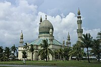 Kampong Pandan Mosque
 -
 Menara Cendera Kenangan
 -
 Mohammad Jamalul Alam Mosque
 -
 Silver Jubilee Park
 -


.jpg)


Sister cities/towns
Notes
- ^ "Direktori Penghulu, Ketua Kampung, dan Ketua Rumah Panjang - Awang Mohammad Sufrizal Bin Haji Hamdan". www.belait.gov.bn. Retrieved 2023-01-11.
- ^ a b "Population and Housing Census Update Final Report 2016" (PDF). www.deps.gov.bn. Department of Statistics. December 2018. Retrieved 29 June 2021.
- ^ Gin, Ooi Keat (2013-05-29). Post-War Borneo, 1945-1950: Nationalism, Empire and State-Building. Routledge. p. 1950. ISBN 978-1-134-05810-5.
- ^ a b c Atiyah, Jeremy (2002). Southeast Asia. Rough Guides. p. 83. ISBN 978-1-85828-893-2.
- ^ USA, IBP (2009-03-20). Brunei Ecology and Nature Protection Handbook. Lulu.com. p. 61. ISBN 978-1-4387-0633-7.
- ^ "Belait District" (PDF). www.information.gov.bn. p. 8. Retrieved 2018-02-28.
- ^ Ledesma, Charles de; Lewis, Mark; Savage, Pauline (2003). Malaysia, Singapore and Brunei. Rough Guides. p. 600. ISBN 978-1-84353-094-7.
- ^ Brunei (1974). Annual Report. H.M. Stationery Office. p. 341.
- ^ "Land Transport Department - Brief History". www.jpd.gov.bn. Retrieved 2022-06-12.
- ^ "History of Kuala Belait".
- ^ a b c "Kuala Belait History, History of Kuala Belait, Kuala Belait City Information :: Traveltill.com". Traveltill. Retrieved 2022-06-14.
- ^ a b "Kuala Belait, the Oil Capital". Kuala Belait, the Oil Capital. Retrieved 2022-06-14.
- ^ Office, Great Britain Colonial (1930). Colonial Reports - Annual. H.M. Stationery Office. p. 12.
- ^ Office, Great Britain Colonial (1936). Colonial Reports - Annual. H.M. Stationery Office. p. 17.
- ^ Brunei, Muzium (1994). Brunei Museum journal. The Museum. p. 35.
- ^ Cleary, Mark; Wong, Shuang Yann (2016-07-27). Oil, Economic Development and Diversification in Brunei Darussalam. Springer. p. 44. ISBN 978-1-349-23485-1.
- ^ Saunders, Graham (2013-11-05). A History of Brunei. Routledge. p. 121. ISBN 978-1-136-87394-2.
- ^ Gin, Ooi Keat (2010-12-17). The Japanese Occupation of Borneo, 1941-45. Routledge. ISBN 978-1-136-96309-4.
- ^ "The Soldier's Burden". www.kaiserscross.com. Retrieved 2022-06-14.
- ^ James, David H. (2010-11-01). The Rise and Fall of the Japanese Empire. Routledge. p. 253. ISBN 978-1-136-92547-4.
- ^ Malone, Paul (2020). Kill the Major: The true story of the most successful Allied guerrilla war in Borneo. For Pity Sake Publishing. ISBN 978-0-6487587-4-7.
- ^ Felton, Mark (2010-06-19). The Final Betrayal: MacArthur and the Tragedy of Japanese POWs. Pen and Sword. ISBN 978-1-84468-478-6.
- ^ Pratten, Garth (2016). Australia 1944–45: Victory in the Pacific. Port Melbourne, Victoria: Cambridge University Press. pp. 298–319. ISBN 978-1-107-08346-2.
- ^ Affairs, Royal Institute of International (1990). Chronology and Index of the Second World War, 1938-1945. Greenwood Publishing Group. ISBN 978-0-88736-568-3.
- ^ Saunders, Graham (2013-11-05). A History of Brunei. Routledge. p. 126. ISBN 978-1-136-87394-2.
- ^ Office, Great Britain Colonial (1955). An Economic Survey of the Colonial Territories. p. 99.
- ^ Kedit, Peter Mulok (1998). 150 Years of the Anglican Church in Borneo. Diocesan Registry. ISBN 978-983-99395-0-7.
- ^ Sidhu, Jatswan S. (2009-12-22). Historical Dictionary of Brunei Darussalam. Scarecrow Press. p. 126. ISBN 978-0-8108-7078-9.
- ^ Sidhu, Jatswan S. (2009-12-22). Historical Dictionary of Brunei Darussalam. Scarecrow Press. p. 167. ISBN 978-0-8108-7078-9.
- ^ Mikoley, Kate (2021-12-15). Brunei. Cavendish Square Publishing, LLC. p. 49. ISBN 978-1-5026-6307-8.
- ^ Asian Survey. University of California Press. 1961. p. 177.
- ^ Ness, Gayl D. (1962). Letters from Southeast Asia to the Institute of Current World Affairs. p. 4.
- ^ Ooi, Keat Gin (2004). Southeast Asia: A Historical Encyclopedia, from Angkor Wat to East Timor. ABC-CLIO. p. 278. ISBN 978-1-57607-770-2.
-
^ 26th 1995; Commission, European; Group, Taylor & Francis (December 1994).
The Far East and Australasia. Europa Publications. p. 167.
ISBN
978-1-85743-000-4.
{{
cite book}}
: CS1 maint: numeric names: authors list ( link) - ^ "Belait District" (PDF). Information Department, Prime Minister's Office | Brunei Darussalam.
- ^ "Home - Jabatan Bandaran Kuala Belait dan Seria, Kementerian Hal Ehwal Dalam Negeri". bandaran-kb.gov.bn. Retrieved 2017-08-29.
- ^ "Kementerian Hal Ehwal Dalam Negeri, Negara Brunei Darussalam - Ketua-Ketua Jabatan". www.moha.gov.bn. Archived from the original on 2021-03-07. Retrieved 2017-08-29.
- ^ About BSP – History of Oil and Gas Archived 15 May 2007 at the Wayback Machine – retrieved 18-04-2007
- ^ a b c "public-notification-domestic-gas-feb-2021" (PDF). 2021.
-
^ Inc, IBP (2016-05-14).
Brunei Business and Investment Opportunities Yearbook Volume 1 Strategic Information and Opportunities. Lulu.com. p. 103.
ISBN
978-1-4387-0627-6.
{{ cite book}}:|last=has generic name ( help) - ^ The Report: Brunei Darussalam 2009. Oxford Business Group. 2009. p. 81. ISBN 978-1-907065-09-5.
- ^ Anthropos. Zaunrith'sche Buch-, Kunst- und Steindruckerei. 1996. p. 202.
- ^ Saunders, Graham (2013-11-05). A History of Brunei. Routledge. p. 119. ISBN 978-1-136-87394-2.
- ^ Brunei (1948). Annual Report on the Social and Economic Progress of the People of Brunei. Printed at the Brunei Press. p. 11.
- ^ Phillips, David R. (2002). Ageing in the Asia-Pacific Region: Issues, Policies and Future Trends. Routledge. p. 324. ISBN 978-1-134-60036-6.
- ^ Rao, Shangdong (2000). Demographic Trends in Negara Brunei Darussalam. Educational Technology Centre, Universiti Brunei Darussalam. p. 18.
- ^ "Kuala Belait climate: Average Temperature, weather by month, Kuala Belait water temperature - Climate-Data.org". en.climate-data.org. Retrieved 2022-06-12.
- ^ Thiessen, Tamara (2008). Bradt Travel Guide - Borneo. Bradt Travel Guides. p. 147. ISBN 978-1-84162-252-1.
-
^ activ8bn.
"Scenic Belait River (Day Cruise)". Brunei Tourism. Retrieved 2022-06-12.
{{
cite web}}
: CS1 maint: numeric names: authors list ( link) - ^ "Kuala Belait Boat Club". Panaga Club. Retrieved 2022-06-12.
- ^ Area, Allied Forces South West Pacific. Terrain Study No. Allied Geographical Section. p. 105.
- ^ Page, Kogan (2003). Asia and Pacific Review 2003/04: The Economic and Business Report. Kogan Page Publishers. p. 222. ISBN 978-0-7494-4063-3.
-
^ Inc, IBP.
Brunei Customs, Trade Regulations and Procedures Handbook Volume 1 Strategic Information and Basic Regulations. Lulu.com. p. 96.
ISBN
978-1-4387-0631-3.
{{ cite book}}:|last=has generic name ( help) - ^ Office, United States Naval Oceanographic. Sailing Directions for Soenda Strait and the Western and Northeast Coasts of Borneo and Offlying Islands. pp. 220a.
- ^ Page, Kogan (2003). Asia and Pacific Review 2003/04: The Economic and Business Report. Kogan Page Publishers. p. 39. ISBN 978-0-7494-4063-3.
- ^ "KUALA BELAIT BREAKWATER EA". iec-brunei.com. Retrieved 2022-06-12.
-
^ Inc, IBP (2016-05-14).
Brunei Business and Investment Opportunities Yearbook Volume 1 Strategic Information and Opportunities. Lulu.com. p. 182.
ISBN
978-1-4387-0627-6.
{{ cite book}}:|last=has generic name ( help) - ^ "Hospital in Kuala Belait - Hospital Near Me". hospitalnearme.net. Retrieved 2022-06-12.
- ^ "Embassy". Information Department, Prime Minister's Office. Retrieved 2023-08-06.
- ^ a b c "Place of Attraction in Belait". GREEN BRUNEI.
- ^ "Call for KB tea pot to light up again » Borneo Bulletin Online". Call for KB tea pot to light up again. 2021-06-30. Retrieved 2022-06-14.
- ^ "SenaraiMasjid - All Pictures". www.kheu.gov.bn. Retrieved 2022-06-14.
- ^ "SenaraiMasjid - All Pictures". www.kheu.gov.bn. Retrieved 2022-06-14.
- ^ "Istana Manggalela". Istana Manggalela. Retrieved 2022-06-14.
-
^ activ8bn.
"5 spectacular sunset spots around Brunei". Brunei Tourism. Retrieved 2022-06-27.
{{
cite web}}
: CS1 maint: numeric names: authors list ( link) - ^ Sidhu, Jatswan S. (2009-12-22). Historical Dictionary of Brunei Darussalam. Scarecrow Press. p. 248. ISBN 978-0-8108-7078-9.
- ^ "Double gold for Fakhri at Brunei Open". BruSports News. 2017-03-21. Retrieved 2023-08-15.
- ^ "Pehin Hong Kok Tin 方国珍 – Biography". Memories of The Way We Were. 2018-12-16. Retrieved 2023-09-17.
- ^ Wong, Aaron (2018-12-17). "At 86, business icon Hj Adnin is determined to champion Brunei's ceramic making". Biz Brunei. Retrieved 2023-07-20.
- ^ Zurah, Abu (2023-12-18). "Berita Keluarga". Berita Keluarga Brunei Darussalam. Retrieved 2023-12-19.
- ^ "Pengiran Anak Jaga Meninggal Dunia" (PDF). Pelita Brunei. 1967-04-05. p. 1. Retrieved 2023-10-21.
- ^ "Christina Koning". The Royal Literary Fund. Retrieved 2021-05-31.
- ^ "TIGER.LIM™: Happy Birthday To Me!!!". www.tigerlim.com. Archived from the original on 2010-09-07.
- ^ a b "Keluaran Khas Sempena Pelantikan Menteri-Menteri Kabinet dan Timbalan-Timbalan Menteri" (PDF). Pelita Brunei. 12 June 2010. pp. 3, 7.
- ^ "Battered but still standing". The Brunei Times. 29 November 2013. Retrieved 4 August 2017.
- ^ "Negara Brunei Darussalam: obituary 2008. - Free Online Library". www.thefreelibrary.com. Retrieved 2023-08-19.
External links
| International | |
|---|---|
| National | |