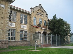
Friscoville Street Historic District | |
 | |
| Location | 100-900 blocks of Friscoville St., Arabi, Louisiana |
|---|---|
| Coordinates | 29°57′01″N 90°00′04″W / 29.95028°N 90.00111°W |
| Area | 16 acres (6.5 ha) |
| Built | 1906 |
| Architectural style | Colonial Revival, Bungalow/craftsman |
| NRHP reference No. | 98000837 [1] |
| Added to NRHP | July 9, 1998 |
The Friscoville Street Historic District, in Arabi, Louisiana in St. Bernard Parish, Louisiana, is a 16 acres (6.5 ha) historic district which was listed on the National Register of Historic Places in 1998. It included 76 contributing buildings. [1]
It includes the 100-900 blocks of Friscoville Street, which was platted in 1906. The district is mostly residential. Besides houses, there are a church, a historic jail, a small commercial building, a brick school, and former casino. It includes Colonial Revival and Bungalow architecture plus scattered eclectic houses. [2]
References
- ^ a b "National Register Information System". National Register of Historic Places. National Park Service. November 2, 2013.
- ^ National Register Staff, Louisiana Division of Historic Preservation (March 1998). "National Register of Historic Places Registration: Friscoville Street Historic District". National Park Service. Retrieved March 24, 2019. With accompanying 21 photos from 1998
