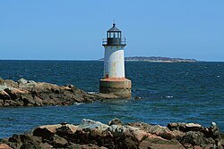
 US Coast Guard photo | |
|
| |
| Location | Salem, Massachusetts |
|---|---|
| Coordinates | 42°31′35.3″N 70°51′59.3″W / 42.526472°N 70.866472°W |
| Tower | |
| Constructed | 1871 |
| Foundation | Concrete |
| Construction | Cast iron and brick |
| Automated | solar 1995 |
| Shape | Conical tower |
| Markings | White |
| Heritage | National Register of Historic Places contributing property
|
| Light | |
| First lit | 1983
|
| Deactivated | 1969-1983 |
| Focal height | 28 feet (8.5 m) |
| Characteristic | Fl W 4s |
Fort Pickering Light | |
 2008 | |
| Location | Salem, Massachusetts |
| Area | 45 acres (18 ha) |
| Architectural style | Multiple |
| Part of | Winter Island Historic District and Archeological District ( ID94000335 [1]) |
| Designated CP | April 14, 1994 |
Fort Pickering Light, also known as Winter Island Light, is a lighthouse built in 1871 and discontinued by the Coast Guard in 1969. [2] [3] It was relit as a private aid to navigation by the City of Salem in 1983.
Winter Island Light is a constituent part of the Winter Island Historic District and Archeological District, which was added to the National Register of Historic Places on April 14, 1994.
See also
- National Register of Historic Places listings in Salem, Massachusetts
- List of lighthouses in the United States, Massachusetts
- Fort Pickering
References
- ^ "National Register Information System". National Register of Historic Places. National Park Service. March 13, 2009.
- ^ "Historic Light Station Information and Photography: Massachusetts". United States Coast Guard Historian's Office. September 2, 2009. Archived from the original on May 1, 2017.
- ^ Light List, Volume I, Atlantic Coast, St. Croix River, Maine to Shrewsbury River, New Jersey (PDF). Light List. United States Coast Guard. 2013. p. 84.
Categories:
- Lighthouses completed in 1871
- Lighthouses on the National Register of Historic Places in Massachusetts
- Buildings and structures in Salem, Massachusetts
- Lighthouses in Essex County, Massachusetts
- Historic district contributing properties in Massachusetts
- 1871 establishments in Massachusetts
- National Register of Historic Places in Salem, Massachusetts
- United States lighthouse stubs
- Essex County, Massachusetts Registered Historic Place stubs
