
Size of this PNG preview of this SVG file:
398 × 599 pixels. Other resolutions:
159 × 240 pixels |
319 × 480 pixels |
510 × 768 pixels |
680 × 1,024 pixels |
1,360 × 2,048 pixels |
1,415 × 2,130 pixels.
Original file (SVG file, nominally 1,415 × 2,130 pixels, file size: 4.46 MB)
| This is a file from the
Wikimedia Commons. Information from its
description page there is shown below. Commons is a freely licensed media file repository. You can help. |
Summary
| Description |
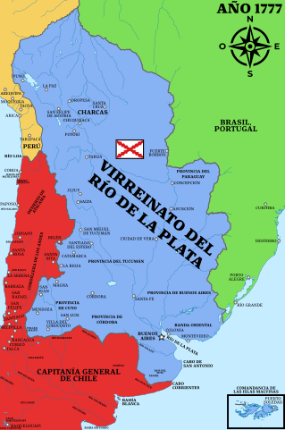
Español: Virreinato del Río de la Plata, 1777, límites basados en el Mapa de Juan de la Cruz Cano y Olmedilla usado por el rey para crear el virreinato y el Tratado de San Ildefonso de 1777. |
||||||||||||||||||||
| Date | |||||||||||||||||||||
| Source |
Own work Mapa geográfico de América Meridional, Juan de la Cruz Cano y Olmedilla, 1775 (láminas juntas).jpg Virreinato del Perú (1810).svg Brazil in 1822.svg Límite entre Chile y Perú en el río Loa, Plano General del Reyno de Chile en la América Meridional de Andrés Baleato (1793).jpg |
||||||||||||||||||||
| Author |
Andrés Baleato
|
||||||||||||||||||||
.jpg)
.svg)
.jpg)
Licensing
I, the copyright holder of this work, hereby publish it under the following license:
This file is licensed under the
Creative Commons
Attribution-Share Alike 4.0 International license.
- You are free:
- to share – to copy, distribute and transmit the work
- to remix – to adapt the work
- Under the following conditions:
- attribution – You must give appropriate credit, provide a link to the license, and indicate if changes were made. You may do so in any reasonable manner, but not in any way that suggests the licensor endorses you or your use.
- share alike – If you remix, transform, or build upon the material, you must distribute your contributions under the same or compatible license as the original.
File history
Click on a date/time to view the file as it appeared at that time.
| Date/Time | Thumbnail | Dimensions | User | Comment | |
|---|---|---|---|---|---|
| current | 20:19, 4 December 2022 |
| 1,415 × 2,130 (4.46 MB) | Janitoalevic | Provincia de Córdoba |
| 22:41, 30 November 2022 |
 | 1,415 × 2,130 (4.49 MB) | Janitoalevic | Texto | |
| 22:38, 30 November 2022 |
 | 1,415 × 2,130 (3.41 MB) | Janitoalevic | Uploaded own work with UploadWizard |
File usage
The following pages on the English Wikipedia use this file (pages on other projects are not listed):
Global file usage
The following other wikis use this file:
- Usage on fr.wikipedia.org