
Size of this PNG preview of this TIF file:
799 × 265 pixels. Other resolutions:
320 × 106 pixels |
640 × 212 pixels |
1,024 × 340 pixels |
1,280 × 425 pixels |
2,560 × 849 pixels |
7,592 × 2,519 pixels.
Original file (7,592 × 2,519 pixels, file size: 72.96 MB, MIME type: image/tiff)
| This is a file from the
Wikimedia Commons. Information from its
description page there is shown below. Commons is a freely licensed media file repository. You can help. |
Summary
| Description |
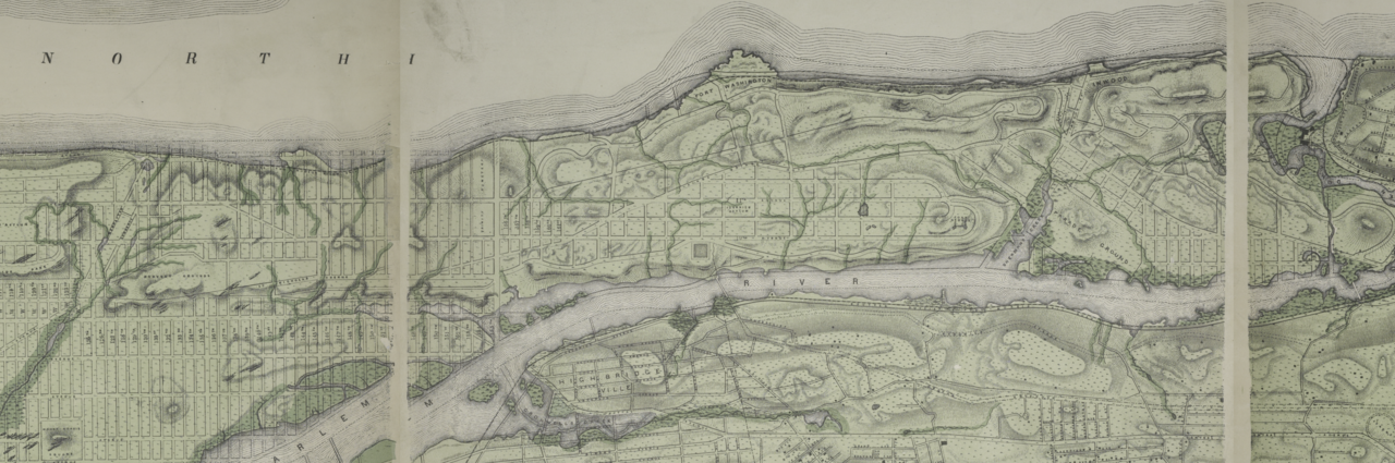
English: Topographical atlas of the city of New York, including the annexed territory showing original water courses and made land.; Atlases of New York city. / Topographical atlas of the city of New York, including the annexed territory showing original water courses and made land / prepared under the direction of Egbert L. Viele. |
|||
| Catalogue call number | Map Div.+++ (New York City) (Viele, E. L. Topographical atlas of the city of New York) | |||
| Date | ||||
| Source | http://digitalgallery.nypl.org/nypldigital/dgkeysearchdetail.cfm?imageID=1527362 | |||
| Author | Egbert L. (Egbert Ludovicus), 1825-1902 -- Cartographer Viele | |||
| Permission ( Reusing this file) |
From The Lionel Pincus and Princess Firyal Map Division. http://maps.nypl.org
|
|||
| Other versions | ||||
| Source description | 1 atlas (5 leaves of plates) : 5 col. maps ; 52 x 72 cm. | |||
| Location | Stephen A. Schwarzman Building / The Lionel Pincus and Princess Firyal Map Division | |||
| Digital item published | 7-25-2006; updated 3-25-2011 | |||
| Digital ID | 1527362 |
Licensing
| This file is made available under the Creative Commons CC0 1.0 Universal Public Domain Dedication. | |
| The person who associated a work with this deed has dedicated the work to the
public domain by waiving all of their rights to the work worldwide under copyright law, including all related and neighboring rights, to the extent allowed by law. You can copy, modify, distribute and perform the work, even for commercial purposes, all without asking permission.
|
File history
Click on a date/time to view the file as it appeared at that time.
| Date/Time | Thumbnail | Dimensions | User | Comment | |
|---|---|---|---|---|---|
| current | 20:34, 6 February 2021 |
| 7,592 × 2,519 (72.96 MB) | The Spirit of Oohoowahoo | Uploaded a work by Egbert L. (Egbert Ludovicus), 1825-1902 -- Cartographer Viele from http://digitalgallery.nypl.org/nypldigital/dgkeysearchdetail.cfm?imageID=1527362 with UploadWizard |
File usage
The following pages on the English Wikipedia use this file (pages on other projects are not listed):