
Size of this JPG preview of this TIF file:
800 × 565 pixels. Other resolutions:
320 × 226 pixels |
640 × 452 pixels |
1,024 × 723 pixels |
1,280 × 904 pixels |
2,560 × 1,808 pixels |
5,000 × 3,531 pixels.
Original file (5,000 × 3,531 pixels, file size: 16.84 MB, MIME type: image/tiff)
| This is a file from the
Wikimedia Commons. Information from its
description page there is shown below. Commons is a freely licensed media file repository. You can help. |
Summary
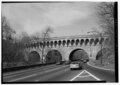
| SOUTHEAST ELEVATION FROM PARKWAY, LOOKING NORTHWEST - Q Street Bridge, Spanning Rock Creek and Potomac Parkway, Washington, District of Columbia, DC | ||||
|---|---|---|---|---|
| Photographer |
Boucher, Jack E. Related names:
|
|||
| Title |
SOUTHEAST ELEVATION FROM PARKWAY, LOOKING NORTHWEST - Q Street Bridge, Spanning Rock Creek and Potomac Parkway, Washington, District of Columbia, DC |
|||
| Depicted place | District of Columbia; District of Columbia; Washington | |||
| Date | 1993 | |||
| Dimensions | 5 x 7 in. | |||
| Current location |
Library of Congress Prints and Photographs Division Washington, D.C. 20540 USA
http://hdl.loc.gov/loc.pnp/pp.print |
|||
| Accession number |
HAER DC,WASH,594-4 |
|||
| Credit line |
|
|||
| Notes |
|
|||
| Source | https://www.loc.gov/pictures/item/dc0775.photos.047876p | |||
| Permission ( Reusing this file) |
|
|||

| Camera location |
| View this and other nearby images on: OpenStreetMap |
|
|---|
File history
Click on a date/time to view the file as it appeared at that time.
| Date/Time | Thumbnail | Dimensions | User | Comment | |
|---|---|---|---|---|---|
| current | 17:24, 10 July 2014 |
 | 5,000 × 3,531 (16.84 MB) | Fæ | GWToolset: Creating mediafile for Fæ. HABS 08 July 2014 (701:800) |
File usage
The following pages on the English Wikipedia use this file (pages on other projects are not listed):
Global file usage
The following other wikis use this file:
- Usage on fr.wikipedia.org
- Usage on www.wikidata.org