
Size of this JPG preview of this TIF file:
800 × 573 pixels. Other resolutions:
320 × 229 pixels |
640 × 459 pixels |
1,024 × 734 pixels |
1,280 × 917 pixels |
2,560 × 1,835 pixels |
4,993 × 3,578 pixels.
Original file (4,993 × 3,578 pixels, file size: 17.04 MB, MIME type: image/tiff)
| This is a file from the
Wikimedia Commons. Information from its
description page there is shown below. Commons is a freely licensed media file repository. You can help. |
Summary
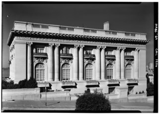
| October 1960 SOUTH ELEVATION - Spreckels Mansion, 2080 Washington Street, San Francisco, San Francisco County, CA | ||||
|---|---|---|---|---|
| Photographer |
Boucher, Jack E. Related names:
|
|||
| Title |
October 1960 SOUTH ELEVATION - Spreckels Mansion, 2080 Washington Street, San Francisco, San Francisco County, CA |
|||
| Depicted place | California; San Francisco County; San Francisco | |||
| Date | Documentation compiled after 1933 | |||
| Dimensions | 5 x 7 in. | |||
| Current location |
Library of Congress Prints and Photographs Division Washington, D.C. 20540 USA
http://hdl.loc.gov/loc.pnp/pp.print |
|||
| Accession number |
HABS CAL,38-SANFRA,74-1 |
|||
| Credit line |
|
|||
| Notes |
|
|||
| Source | https://www.loc.gov/pictures/item/ca0726.photos.016969p | |||
| Permission ( Reusing this file) |
|
|||

| Camera location |
| View this and other nearby images on: OpenStreetMap |
|
|---|
File history
Click on a date/time to view the file as it appeared at that time.
| Date/Time | Thumbnail | Dimensions | User | Comment | |
|---|---|---|---|---|---|
| current | 00:01, 4 July 2014 |
 | 4,993 × 3,578 (17.04 MB) | Fæ | GWToolset: Creating mediafile for Fæ. HABS 3 July 2014 (201:300) |
File usage
The following pages on the English Wikipedia use this file (pages on other projects are not listed):
Global file usage
The following other wikis use this file:
- Usage on en.wikivoyage.org
- Usage on www.wikidata.org