Size of this preview:
800 × 458 pixels. Other resolutions:
320 × 183 pixels |
825 × 472 pixels.
Original file (825 × 472 pixels, file size: 31 KB, MIME type: image/png)
| This is a file from the
Wikimedia Commons. Information from its
description page there is shown below. Commons is a freely licensed media file repository. You can help. |
| Description |
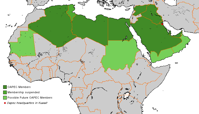
English: Oapec members... with current suspended and possible members |
| Date | 16 August 2007 (original upload date) |
| Source | Transferred from en.wikipedia to Commons by Leyo using CommonsHelper. |
| Author | Arab League at English Wikipedia |
Licensing
| This work has been released into the
public domain by its author,
Arab League at
English Wikipedia. This applies worldwide. In some countries this may not be legally possible; if so: Arab League grants anyone the right to use this work for any purpose, without any conditions, unless such conditions are required by law. |
Original upload log
The original description page was
here. All following user names refer to en.wikipedia.
- 2007-08-16 14:39 Arab League 825×472× (35021 bytes)
- 2007-08-16 14:24 Arab League 825×472× (35044 bytes) Oapec members... with current suspended and possible members

|
This organization map image could be re-created using
vector graphics as an
SVG file. This has several advantages; see
Commons:Media for cleanup for more information. If an SVG form of this image is available, please upload it and afterwards replace this template with
{{
vector version available|new image name}}
.
It is recommended to name the SVG file “OAPEC Members.svg”—then the template Vector version available (or Vva) does not need the new image name parameter. |
File history
Click on a date/time to view the file as it appeared at that time.
| Date/Time | Thumbnail | Dimensions | User | Comment | |
|---|---|---|---|---|---|
| current | 11:15, 7 March 2018 |
| 825 × 472 (31 KB) | Maphobbyist | Check |
| 12:18, 6 March 2018 |
 | 825 × 472 (34 KB) | Maphobbyist | Modern borders of Turkey, because Hatay Province is part of Turkey since 1939 and borders of South Sudan which became independent in 2011. | |
| 20:58, 28 April 2015 |
 | 825 × 472 (29 KB) | Maproom | Reverted to version as of 01:02, 3 July 2010 | |
| 20:56, 28 April 2015 |
 | 825 × 472 (27 KB) | Maproom | Greyed Sudan, as requested English-Wikipedia Help Desk: /info/en/?search=Wikipedia:Graphics_Lab/Map_workshop#OAPAC_members_-_South_Sudan | |
| 01:02, 3 July 2010 |
 | 825 × 472 (29 KB) | Dcoetzee | Remove watermark | |
| 10:01, 20 November 2008 |
 | 825 × 472 (34 KB) | File Upload Bot (Magnus Manske) | {{BotMoveToCommons|en.wikipedia}} {{Information |Description={{en|Oapec members... with current suspended and possible members}} |Source=Transferred from [http://en.wikipedia.org en.wikipedia]; transferred to Commons by User:Leyo using [http://tools. |
File usage
The following pages on the English Wikipedia use this file (pages on other projects are not listed):
Global file usage
The following other wikis use this file:
- Usage on ar.wikipedia.org
- Usage on da.wikipedia.org
- Usage on de.wikipedia.org
- Usage on el.wikipedia.org
- Usage on eo.wikipedia.org
- Usage on es.wikipedia.org
- Usage on he.wikipedia.org
- Usage on hi.wikipedia.org
- Usage on hr.wikipedia.org
- Usage on it.wikipedia.org
- Usage on ja.wikipedia.org
- Usage on km.wikipedia.org
- Usage on ko.wikipedia.org
- Usage on ne.wikipedia.org
- Usage on nl.wikipedia.org
- Usage on no.wikipedia.org
- Usage on pl.wikipedia.org
- Usage on pt.wikipedia.org
- Usage on ro.wikipedia.org
- Usage on ru.wikipedia.org
- Usage on sv.wikipedia.org
- Usage on ta.wikipedia.org
- Usage on tr.wikipedia.org
- Usage on uk.wikipedia.org
- Usage on www.wikidata.org