No higher resolution available.
Myrtle_Beach-Conway-Georgetown_CSA.png (541 × 437 pixels, file size: 30 KB, MIME type: image/png)
| This is a file from the
Wikimedia Commons. Information from its
description page there is shown below. Commons is a freely licensed media file repository. You can help. |
| Description |
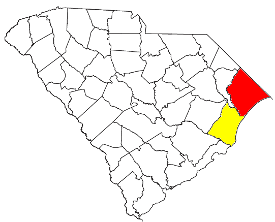
Locator map of the Myrtle Beach-Conway-Georgetown Combined Statistical Area in the eastern part of the U.S. state of South Carolina. The two components of the CSA are colored separately: |
||
| Date | |||
| Source |
Modified from this United States Census Bureau file, based on the following Census definitions lists: |
||
| Author | User:Nyttend | ||
| Permission ( Reusing this file) |
US Government work is public domain, and my work is
|
File history
Click on a date/time to view the file as it appeared at that time.
| Date/Time | Thumbnail | Dimensions | User | Comment | |
|---|---|---|---|---|---|
| current | 15:48, 2 August 2008 |
| 541 × 437 (30 KB) | Nyttend | {{Information |Description=Locator map of the {{w|Myrtle Beach-Conway-Georgetown, SC CSA|Myrtle Beach-Conway-Georgetown}} {{w|Combined Statistical Area}} in the eastern part of the {{w|U.S. state}} of {{w|South Carolina}}. The two components of the CSA a |
File usage
More than 100 pages use this file. The following list shows the first 100 pages that use this file only. A full list is available.
- Myrtle Beach, South Carolina
- Talk:2009–10 Coastal Carolina Chanticleers men's basketball team
- Talk:2010 Coastal Carolina Chanticleers football team
- Talk:2010–11 Coastal Carolina Chanticleers men's basketball team
- Talk:2011 Coastal Carolina Chanticleers football team
- Talk:2011–12 Coastal Carolina Chanticleers men's basketball team
- Talk:2012 Coastal Carolina Chanticleers football team
- Talk:2012–13 Coastal Carolina Chanticleers men's basketball team
- Talk:2013 Coastal Carolina Chanticleers football team
- Talk:2013–14 Coastal Carolina Chanticleers men's basketball team
- Talk:2014 Coastal Carolina Chanticleers football team
- Talk:2014–15 Coastal Carolina Chanticleers men's basketball team
- Talk:2015 Coastal Carolina Chanticleers football team
- Talk:2015–16 Coastal Carolina Chanticleers men's basketball team
- Talk:2016 Coastal Carolina Chanticleers baseball team
- Talk:2016 Coastal Carolina Chanticleers football team
- Talk:2016–17 Coastal Carolina Chanticleers men's basketball team
- Talk:Briarcliffe Acres, South Carolina
- Talk:Broadway at the Beach
- Talk:Brooks Stadium
- Talk:Burgess, South Carolina
- Talk:Cherry Grove Beach, South Carolina
- Talk:Coastal Carolina Chanticleers
- Talk:Coastal Carolina Chanticleers baseball
- Talk:Coastal Carolina Chanticleers football
- Talk:Coastal Carolina Chanticleers football statistical leaders
- Talk:Coastal Carolina Chanticleers men's basketball
- Talk:Coastal Carolina University
- Talk:Coastal Grand Mall
- Talk:Conway, South Carolina
- Talk:Crescent Beach, South Carolina
- Talk:Family Kingdom Amusement Park
- Talk:Farrow Parkway
- Talk:Forestbrook, South Carolina
- Talk:Freestyle Music Park
- Talk:Garden City, South Carolina
- Talk:HTC Center
- Talk:Harrelson Boulevard
- Talk:Hickory Grove, Horry County, South Carolina
- Talk:Homewood, South Carolina
- Talk:Horry County, South Carolina
- Talk:Inlet Square Mall
- Talk:Kiera Cass
- Talk:List of Coastal Carolina Chanticleers football seasons
- Talk:Little River, South Carolina
- Talk:MagiQuest
- Talk:Matt Hazel
- Talk:Meher Spiritual Center
- Talk:Mike Tolbert
- Talk:Myrtle Beach, South Carolina
- Talk:Myrtle Beach High School
- Talk:Myrtle Beach International Airport
- Talk:Myrtle Beach Pelicans
- Talk:Myrtle Square Mall
- Talk:North Myrtle Beach, South Carolina
- Talk:Robert Grissom Parkway
- Talk:Socastee, South Carolina
- Talk:South Carolina Highway 22
- Talk:South Carolina Highway 31
- Talk:South Carolina Highway 544
- Talk:South Carolina Highway 707
- Talk:Springmaid Beach, South Carolina
- Talk:Springs Brooks Stadium
- Talk:Sun Belt Conference
- Talk:Surfside Beach, South Carolina
- Talk:TPC of Myrtle Beach
- Talk:U.S. Route 501
- Talk:WBTW
- Talk:WFXB
- User:Crtrue/MBTest
- User:Crtrue/MB Trial
- User talk:Hurricanefan25 in the storm/Archive 1
- User talk:KumiokoCleanStart/Archive 10
- User talk:KumiokoCleanStart/Archive 9
- User talk:Oldiesmann
- User talk:Polikol22
- User talk:Presidentman/Archives/ 4
- User talk:Presidentman/Archives/ 5
- Wikipedia:WikiProject Iowa
- Wikipedia:WikiProject Nebraska
- Wikipedia:WikiProject United States
- Wikipedia:WikiProject United States/Newsletter/December 2011
- Wikipedia:WikiProject United States/Newsletter/January 2012
- Wikipedia:WikiProject United States/Newsletter/September 2011
- Wikipedia:WikiProject United States/Projects supported
- Wikipedia talk:WikiProject Myrtle Beach
- Wikipedia talk:WikiProject Myrtle Beach/to do
- File talk:Coastal Carolina Wordmark.png
- Template:WikiProject United States
- Template:WikiProject United States/sandbox
- Template talk:2016 Coastal Carolina Chanticleers baseball
- Template talk:Coastal Carolina Chanticleers athletic director navbox
- Template talk:Coastal Carolina Chanticleers baseball navbox
- Template talk:Coastal Carolina Chanticleers football coach navbox
- Template talk:Coastal Carolina Chanticleers football navbox
- Template talk:Coastal Carolina Chanticleers men's basketball coach navbox
- Template talk:Coastal Carolina Chanticleers men's basketball navbox
- Category talk:Coastal Carolina Chanticleers baseball navigational boxes
- Category talk:Coastal Carolina Chanticleers football navigational boxes
- Category talk:Coastal Carolina Chanticleers men's basketball navigational boxes
View more links to this file.
Global file usage
The following other wikis use this file:
- Usage on it.wikipedia.org
- Usage on www.wikidata.org