Size of this preview:
511 × 599 pixels. Other resolutions:
205 × 240 pixels |
409 × 480 pixels |
1,000 × 1,172 pixels.
Original file (1,000 × 1,172 pixels, file size: 544 KB, MIME type: image/png)
File history
Click on a date/time to view the file as it appeared at that time.
| Date/Time | Thumbnail | Dimensions | User | Comment | |
|---|---|---|---|---|---|
| current | 01:49, 28 March 2011 |
 | 1,000 × 1,172 (544 KB) | Kmusser | higher resolution, more detailed map |
| 22:21, 27 March 2011 |
 | 420 × 421 (36 KB) | Kmusser | Reverted to version as of 20:29, 26 October 2010 - that looks terrible, additions don't match scale of the map - I can work on a more detailed version | |
| 20:01, 27 March 2011 |
 | 268 × 428 (48 KB) | Target for Today | Rock Creek portion of watershed was inaccurate (http://adamswatersheds.org/images/RockFact.pdf), Alloway Cr & Gettysburg were missing, Westminster MD & better Monocacy & Potomac clarity needed added | |
| 20:29, 26 October 2010 |
 | 420 × 421 (36 KB) | Kmusser | trimmed | |
| 21:07, 18 May 2006 |
 | 450 × 450 (33 KB) | Kmusser | ||
| 20:13, 18 May 2006 |
 | 400 × 400 (28 KB) | Kmusser | ||
| 19:14, 18 May 2006 |
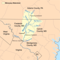
 | 400 × 400 (93 KB) | Kmusser | == Summary == This is a map of the Monocacy River Watershed I made using USGS and Census Bureau data. Category:Maps of rivers |
File usage
The following pages on the English Wikipedia use this file (pages on other projects are not listed):
- Alloway Creek (Monocacy River tributary)
- Carroll Creek (Maryland)
- Double Pipe Creek
- Gettysburg campaign
- Linganore Creek
- List of rivers of Maryland
- Marsh Creek (Monocacy River tributary)
- Middle Creek (Toms Creek tributary)
- Monocacy River
- Toms Creek (Monocacy River tributary)
- Union Mills Reservoir
- User:Kmusser/Images
Global file usage
The following other wikis use this file:
- Usage on arz.wikipedia.org
- Usage on da.wikipedia.org
- Usage on de.wikipedia.org
- Usage on fa.wikipedia.org
- Usage on fr.wikipedia.org
- Usage on it.wikipedia.org
- Usage on pl.wikipedia.org
- Usage on ru.wikipedia.org
- Usage on www.wikidata.org