No higher resolution available.
Mississippi-Coast-towns-NOAA.jpg (750 × 382 pixels, file size: 57 KB, MIME type: image/jpeg)
| This is a file from the
Wikimedia Commons. Information from its
description page there is shown below. Commons is a freely licensed media file repository. You can help. |

|
This map image could be re-created using
vector graphics as an
SVG file. This has several advantages; see
Commons:Media for cleanup for more information. If an SVG form of this image is available, please upload it and afterwards replace this template with
{{
vector version available|new image name}}
.
It is recommended to name the SVG file “Mississippi-Coast-towns-NOAA.svg”—then the template Vector version available (or Vva) does not need the new image name parameter. |


Summary
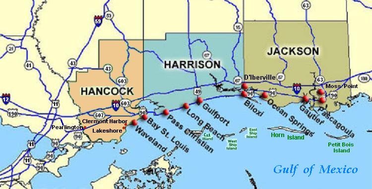
| Description | Coastal map of the U.S. state of Mississippi, showing major towns and cities in the three coastal counties: Hancock, Harrison, and Jackson County. Also shown are Cat Island, West Ship Island, East Ship Island, Horn Island and Petit Bois Island.The locations of towns, roads and offshore islands are based on NOAA and NASA maps. |
| Date | |
| Source |
Own work; self-made (hand-edited with MS-Paint)
Pure stupidity: The map is in quick JPEG format, for large display as highly readable, in about 20 articles that display the map. JPEG clarity is enhanced by painted areas behind many labels, causing the wording to be clearer than even a massive SVG or PNG-format file could provide, due to the sharp display contrast of JPEG files. JPEG Clarity: Even though JPEG images have artifacts, they can display clearer wording in small maps due to auto-contrast enhancement. The same painted/shaded areas, that illuminate wording, would make the map excessively gargantuan in slow cumbersome PNG or SVG format, as is the case with terrain maps, which also should NEVER be converted to massive PNG format. |
| Author | Wikid77 |
Licensing
| This work has been released into the
public domain by its author, I,
Wikid77. This applies worldwide. In some countries this may not be legally possible; if so: I, Wikid77 grants anyone the right to use this work for any purpose, without any conditions, unless such conditions are required by law. |
File history
Click on a date/time to view the file as it appeared at that time.
| Date/Time | Thumbnail | Dimensions | User | Comment | |
|---|---|---|---|---|---|
| current | 02:54, 26 June 2007 |
| 750 × 382 (57 KB) | Wikid77 | Brown-toned map: Hancock County as tan (was green); put "Gulf of Mexico" Antigua font; shift labels on islands |
| 00:17, 26 June 2007 |
 | 750 × 382 (56 KB) | Wikid77 | Mississippi coastal map, with "Horn Island" relabeled, clarified Hwy "90" and "63" icons. | |
| 18:56, 21 June 2007 |
 | 750 × 382 (56 KB) | Wikid77 | re-load of image file, in case internal data was garbled | |
| 18:11, 21 June 2007 |
 | 750 × 382 (56 KB) | Wikid77 | {{Information |Description=Coastal map of the U.S. state of en:Mississippi, showing major towns and cities in the 3 coastal counties: Hancock, Harrison, a |
File usage
The following pages on the English Wikipedia use this file (pages on other projects are not listed):
- Biloxi, Mississippi
- Effects of Hurricane Katrina in Mississippi
- Gautier, Mississippi
- Gulfport, Mississippi
- Hancock County, Mississippi
- Horn Island Chemical Warfare Service Quarantine Station
- Long Beach, Mississippi
- Ocean Springs, Mississippi
- Pascagoula Abduction
- Pearlington, Mississippi
- Ship Island
- Waveland, Mississippi
Global file usage
The following other wikis use this file:
- Usage on ca.wikipedia.org
- Usage on de.wikipedia.org
- Usage on fr.wikipedia.org
- Usage on fy.wikipedia.org
- Usage on he.wikipedia.org
- Usage on hu.wikipedia.org
- Usage on it.wikipedia.org
- Usage on ja.wikipedia.org
- Usage on pt.wikipedia.org
- Usage on tr.wikipedia.org
- Usage on vi.wikipedia.org
- Usage on zh.wikipedia.org