
Size of this JPG preview of this TIF file:
711 × 599 pixels. Other resolutions:
285 × 240 pixels |
570 × 480 pixels |
911 × 768 pixels |
1,215 × 1,024 pixels |
1,946 × 1,640 pixels.
Original file (1,946 × 1,640 pixels, file size: 9.14 MB, MIME type: image/tiff)
| This is a file from the
Wikimedia Commons. Information from its
description page there is shown below. Commons is a freely licensed media file repository. You can help. |
Summary
| Description |
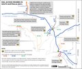
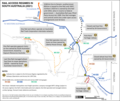
English: Map of rail access regimes in South Australia, 2021.
One Rail Australia (bought out by
Aurizon in July 2022) operated in South Australia and the Northern Territory under a variety of ownership, leasing and access arrangements. The map summarises the arrangements. "Open access" gives access to any qualifying company interested in operating on a line. A number of companies operate on the
ARTC's interstate lines, and OneRail Australia manages open access for
The Ghan on the
Tarcoola to
Darwin line. However, all indications are that no other railway operator will seek to gain access to the dotted lines shown in blue and yellow, because the cause of withdrawal of services was various decisions by grain handler,
Viterra, to abandon rail transport from its silos to port. |
| Date | 1 August 2022 |
| Source | Own work |
| Author | SCHolar44 |
Licensing
I, the copyright holder of this work, hereby publish it under the following license:
| This file is made available under the Creative Commons CC0 1.0 Universal Public Domain Dedication. | |
| The person who associated a work with this deed has dedicated the work to the
public domain by waiving all of their rights to the work worldwide under copyright law, including all related and neighboring rights, to the extent allowed by law. You can copy, modify, distribute and perform the work, even for commercial purposes, all without asking permission.
|
File history
Click on a date/time to view the file as it appeared at that time.
| Date/Time | Thumbnail | Dimensions | User | Comment | |
|---|---|---|---|---|---|
| current | 07:23, 30 November 2022 |
 | 1,946 × 1,640 (9.14 MB) | SCHolar44 | Cropped to match previous version |
| 07:18, 30 November 2022 |
 | 2,338 × 1,653 (14.75 MB) | SCHolar44 | Minor correction (Marree → Leigh Creek) by original uploader | |
| 07:48, 12 August 2022 |
 | 1,943 × 1,641 (12.17 MB) | SCHolar44 | Upgraded Murraylands lines to standard gauge. | |
| 08:50, 1 August 2022 |
 | 1,941 × 1,640 (12.15 MB) | SCHolar44 | Uploaded own work with UploadWizard |
File usage
The following pages on the English Wikipedia use this file (pages on other projects are not listed):