
Size of this preview:
460 × 599 pixels. Other resolutions:
184 × 240 pixels |
368 × 480 pixels |
589 × 768 pixels |
786 × 1,024 pixels |
2,075 × 2,704 pixels.
Original file (2,075 × 2,704 pixels, file size: 634 KB, MIME type: image/jpeg)
| This is a file from the
Wikimedia Commons. Information from its
description page there is shown below. Commons is a freely licensed media file repository. You can help. |
.jpg)
Summary
| Description |
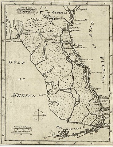
English: Map of Florida of ca. 1764]].
|
| Date | circa 1764 |
| Source | US Library of Congress |
| Author | "Don John de Solís, surveyor, who resided there near twenty years" |
Licensing
|
This work is in the public domain in its country of origin and other countries and areas where the copyright term is the author's life plus 100 years or fewer. | |
| This file has been identified as being free of known restrictions under copyright law, including all related and neighboring rights. | |
File history
Click on a date/time to view the file as it appeared at that time.
| Date/Time | Thumbnail | Dimensions | User | Comment | |
|---|---|---|---|---|---|
| current | 23:06, 27 May 2018 |
| 2,075 × 2,704 (634 KB) | Hispalois | Higher-resolution image. Please note that this map has no relationship whatsoever with 16th-century explorer Juan Díaz de Solís. |
| 17:16, 15 June 2006 |
 | 399 × 500 (49 KB) | Eamezaga | Map published in the US depicting a very accurate shape of Florida (1764), based on an ancient draft drawn by the Spanish-Portuguese explorer and discoverer Juan Díaz de Solís (US Library of Congress, released to public domain) |
File usage
The following pages on the English Wikipedia use this file (pages on other projects are not listed):
Global file usage
The following other wikis use this file:
- Usage on it.wikipedia.org
.jpg)