
Size of this PNG preview of this SVG file:
523 × 599 pixels. Other resolutions:
209 × 240 pixels |
419 × 480 pixels |
670 × 768 pixels |
894 × 1,024 pixels |
1,787 × 2,048 pixels |
1,022 × 1,171 pixels.
Original file (SVG file, nominally 1,022 × 1,171 pixels, file size: 487 KB)
| This is a file from the
Wikimedia Commons. Information from its
description page there is shown below. Commons is a freely licensed media file repository. You can help. |
Summary
| Description | |
| Date | |
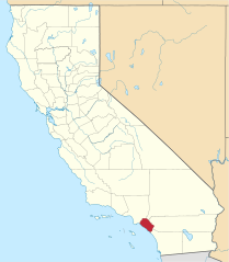
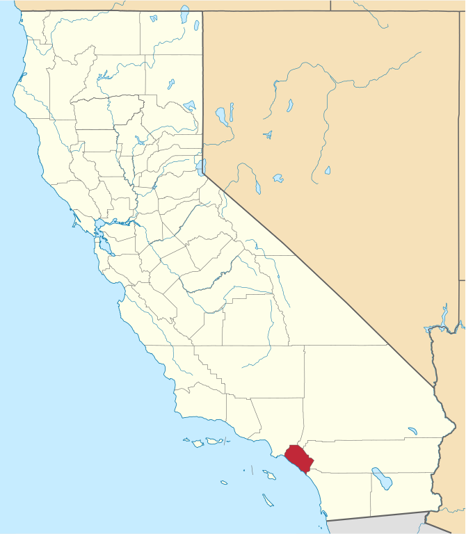
| Source | Own work using: nationalatlas.gov, specifically countyp020.tar.gz on the Raw Data Download page. The maps also use state outline data from statesp020.tar.gz. |
| Author | David Benbennick made this map. |
| Other versions | For more information, see Commons:United States county locator maps. |
| SVG development | This W3C-invalid
locator map was created with
Inkscape. |
Licensing
| I, the copyright holder of this work, release this work into the
public domain. This applies worldwide. In some countries this may not be legally possible; if so: I grant anyone the right to use this work for any purpose, without any conditions, unless such conditions are required by law. |
File history
Click on a date/time to view the file as it appeared at that time.
| Date/Time | Thumbnail | Dimensions | User | Comment | |
|---|---|---|---|---|---|
| current | 18:24, 25 November 2016 |
| 1,022 × 1,171 (487 KB) | Spartan7W | Update to HQ map |
| 07:58, 15 July 2009 |
 | 9,164 × 10,536 (229 KB) | Rastrojo | Reverted to version as of 10:27, 12 February 2006 | |
| 15:08, 15 April 2009 |
 | 9,164 × 10,536 (233 KB) | Matt me | Orange County, California | |
| 10:27, 12 February 2006 |
 | 9,164 × 10,536 (229 KB) | David Benbennick | {{subst:User:Dbenbenn/clm|county=Orange County|state=California}} |
File usage
The following pages on the English Wikipedia use this file (pages on other projects are not listed):
- Aliso Viejo, California
- Anaheim, California
- Anaheim Hills
- Anaheim Island, California
- Atwood, Placentia, California
- Brea, California
- Buena Park, California
- Carbondale, Orange County, California
- Communities of Newport Beach, California
- Corona del Mar, Newport Beach
- Costa Mesa, California
- Coto de Caza, California
- Cypress, California
- Dana Point, California
- El Modena, California
- Emerald Bay, Orange County, California
- Fountain Valley, California
- Frank R. Bowerman Landfill
- Fullerton, California
- Garden Grove, California
- Garden Grove Unified School District
- Huntington Beach, California
- Irvine, California
- La Habra, California
- La Palma, California
- Ladera Ranch, California
- Laguna Beach, California
- Laguna Hills, California
- Laguna Niguel, California
- Laguna Woods, California
- Lake Forest, California
- Las Flores, California
- List of counties in California
- List of museums in Orange County, California
- Los Alamitos, California
- Midway City, California
- Miraflores, California
- Mission Viejo, California
- Modjeska Canyon, California
- Monarch Beach, Dana Point, California
- National Register of Historic Places listings in Orange County, California
- Newport Beach, California
- North Tustin, California
- Orange, California
- Orange Coast
- Orange County, California
- Orange County Sheriff's Department
- Orange Park Acres, California
- Placentia, California
- Rancho Mission Viejo, California
- Rancho Santa Margarita, California
- Rossmoor, California
- San Clemente, California
- San Joaquin Hills (Laguna Niguel, California)
- San Juan Capistrano, California
- Santa Ana, California
- Santiago Canyon, California
- Seal Beach, California
- Silverado, California
- Stanton, California
- Sunset Beach, California
- Trabuco Canyon, California
- Tustin, California
- Villa Park, California
- Westminster, California
- Williams Canyon, California
- Yorba Linda, California
- User:AridCeption/sandbox
- User:CactusJack/California watchlist
- User:Darkest tree/sandbox/List of counties in California
- User:Nyttend/County templates/CA/2
- Template:Orange County, California
- Category:Cities in Southern California
- Category:Populated places in Orange County, California
- Category:Wikipedia requested photographs in Orange County, California
Global file usage
The following other wikis use this file:
- Usage on ar.wikipedia.org
- Usage on arz.wikipedia.org
- Usage on ban.wikipedia.org
- Usage on be.wikipedia.org
- Usage on bpy.wikipedia.org
- Usage on ca.wikipedia.org
- Placentia (Califòrnia)
- Newport Beach
- Santa Ana (Califòrnia)
- Anaheim
- Irvine (Califòrnia)
- Huntington Beach
- Brea (Califòrnia)
- Yorba Linda
- Aliso Viejo
- Buena Park
- Costa Mesa
- Coto de Caza
- Cypress (Califòrnia)
- Dana Point
- Fountain Valley
- Fullerton (Califòrnia)
- Garden Grove
- La Habra
- Laguna Beach
- Laguna Hills
- Laguna Niguel
- Laguna Woods
- Lake Forest (Califòrnia)
- Las Flores (Califòrnia)
- Los Alamitos
- Mission Viejo
- Orange (Califòrnia)
- Rancho Santa Margarita
- Rossmoor (Califòrnia)
- San Clemente (Califòrnia)
- San Juan Capistrano
- Seal Beach
- Stanton (Califòrnia)
- Tustin (Califòrnia)
- Villa Park (Califòrnia)
- Westminster (Califòrnia)
- Comtat d'Orange (Califòrnia)
- Llista de comtats de Califòrnia
- Plantilla:Comtat d'Orange (Califòrnia)
- Usage on ceb.wikipedia.org
- Usage on ce.wikipedia.org
- Usage on cs.wikipedia.org
- Usage on cy.wikipedia.org
- Usage on da.wikipedia.org
View more global usage of this file.