
Size of this preview:
800 × 532 pixels. Other resolutions:
320 × 213 pixels |
640 × 426 pixels |
1,024 × 681 pixels |
1,280 × 851 pixels |
2,560 × 1,702 pixels |
6,016 × 4,000 pixels.
Original file (6,016 × 4,000 pixels, file size: 7.3 MB, MIME type: image/jpeg)
| This is a file from the
Wikimedia Commons. Information from its
description page there is shown below. Commons is a freely licensed media file repository. You can help. |
|
This is an image of a place or building that is listed on the
National Register of Historic Places in the
United States of America. Its reference number is
12000018. |
| Camera location |
| View this and other nearby images on: OpenStreetMap |
|
|---|
| Description |
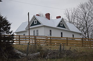
English: Front of the
Junius Marcellus Updyke Farmhouse, located at 4859 E.
State Route 42 east of
Bland in
Bland County,
Virginia,
United States. Built in 1912, it is listed on the
National Register of Historic Places. |
||
| Date | Taken on 11 February 2017 | ||
| Source | Own work | ||
| Author | Nyttend | ||
| Permission ( Reusing this file) |
|
File history
Click on a date/time to view the file as it appeared at that time.
| Date/Time | Thumbnail | Dimensions | User | Comment | |
|---|---|---|---|---|---|
| current | 02:28, 17 February 2017 |
| 6,016 × 4,000 (7.3 MB) | Nyttend | {{NRHP|12000018}} {{Location|37|7|31|N|81|0|59|W}} {{Information |Description={{en|Front of the {{w|Junius Marcellus Updyke Farm|Junius Marcellus Updyke Farmhouse}}, located at 4859 E. {{w|Virginia State Route 42|State Route 42}} east of {{w|Bland, Vir... |
File usage
The following pages on the English Wikipedia use this file (pages on other projects are not listed):
Global file usage
The following other wikis use this file:
- Usage on www.wikidata.org