
Size of this preview:
800 × 183 pixels. Other resolutions:
320 × 73 pixels |
640 × 146 pixels |
1,024 × 234 pixels |
1,280 × 293 pixels |
6,457 × 1,476 pixels.
Original file (6,457 × 1,476 pixels, file size: 11.29 MB, MIME type: image/jpeg)
| This is a file from the
Wikimedia Commons. Information from its
description page there is shown below. Commons is a freely licensed media file repository. You can help. |
|

This image was selected as
picture of the day on Wikimedia Commons for
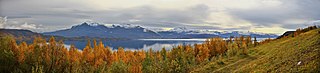
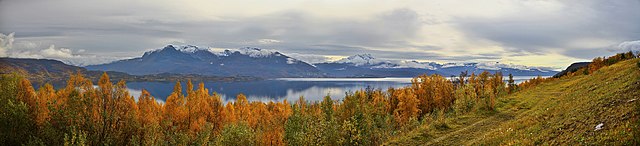
14 April 2011. It was captioned as follows: English: A view over Herjangsfjorden and Ofotfjorden from the north side of the fjord in 2010 September. The fjord is located in the county of Nordland in Norway. Other languages:
Deutsch: Ein Blick über den Herjangsfjord und den
Ofotfjord (von Norden gesehen) – Die Fjorde befinden sich in der Provinz
Nordland in
Norwegen English: A view over Herjangsfjorden and Ofotfjorden from the north side of the fjord in 2010 September. The fjord is located in the county of Nordland in Norway. Español: Vista sobre el
Herjangsfjorden y
Ofotfjorden desde el lado norte del fiordo en septiembre de 2010. El fiordo está situado en el condado de
Nordland (
Noruega). Français : Vue sur le Herjangsfjord et l'Ofotfjord prise depuis la rive nord, en septembre 2010. Au loin, on devine la ville de Narvik. Comté de Nordland, Norvège. |
This image has been assessed using the
Quality image guidelines and is considered a
Quality image.
|
| Description |
English: A view over Herjangsfjorden and Ofotfjorden from the north side of the fjord in 2010 September. The fjord is located in the county of Nordland in Norway.
Suomi: Näkymä Herjangsfjordille ja Ofotvuonolle pohjoispuolelta syyskuussa 2010. Vuono sijaitsee Nordlandin läänissä, Pohjois-Norjassa.
Français : Vue sur le Herjangsfjord et l'Ofotfjord prise depuis la rive nord, en septembre 2010. Au loin, on devine la ville de
Narvik.
Comté de Nordland, Norvège.
Русский: Вид с северного берег ана Херьянгсфьорд и Офотфьорд. Губерния Нордланд, Норвегия, сентябрь 2010 года |
| Date | |
| Source | Own work |
| Author | Ximonic, Simo Räsänen |
| Camera location |
| View this and other nearby images on: OpenStreetMap |
|
|---|

|
Permission is granted to copy, distribute and/or modify this document under the terms of the GNU Free Documentation License, Version 1.2 or any later version published by the Free Software Foundation; with no Invariant Sections, no Front-Cover Texts, and no Back-Cover Texts. A copy of the license is included in the section entitled GNU Free Documentation License. |
| Annotations | This image is annotated: View the annotations at Commons |
File history
Click on a date/time to view the file as it appeared at that time.
| Date/Time | Thumbnail | Dimensions | User | Comment | |
|---|---|---|---|---|---|
| current | 21:30, 5 December 2010 |
| 6,457 × 1,476 (11.29 MB) | Ximonic | Some fringes removed |
| 17:54, 3 December 2010 |
| 6,457 × 1,476 (11.28 MB) | Ximonic | color fixing | |
| 17:41, 3 December 2010 |
| 6,457 × 1,476 (11.29 MB) | Ximonic | color fixing, to match better with the reality | |
| 14:15, 13 November 2010 |
| 6,457 × 1,476 (11.23 MB) | Ximonic |
File usage
The following pages on the English Wikipedia use this file (pages on other projects are not listed):
Global file usage
The following other wikis use this file:
- Usage on be-tarask.wikipedia.org
- Usage on bn.wikipedia.org
- Usage on crh.wikipedia.org
- Usage on cv.wikipedia.org
- Usage on da.wikipedia.org
- Usage on fa.wikipedia.org
- Usage on fi.wikipedia.org
- Usage on hu.wikipedia.org
- Usage on it.wikipedia.org
- Usage on ko.wikipedia.org
- Usage on lbe.wikipedia.org
- Usage on mg.wikipedia.org
- Usage on os.wikipedia.org
- Usage on pl.wikipedia.org
- Usage on ru.wikipedia.org
- Usage on ru.wikinews.org
- Usage on sah.wikipedia.org
- Usage on uk.wikipedia.org
- Usage on vi.wikipedia.org
- Usage on xal.wikipedia.org
- Usage on zh.wikipedia.org