
Size of this JPG preview of this TIF file:
429 × 600 pixels. Other resolutions:
171 × 240 pixels |
343 × 480 pixels |
549 × 768 pixels |
732 × 1,024 pixels |
1,464 × 2,048 pixels |
3,575 × 5,000 pixels.
Original file (3,575 × 5,000 pixels, file size: 17.05 MB, MIME type: image/tiff)
| This is a file from the
Wikimedia Commons. Information from its
description page there is shown below. Commons is a freely licensed media file repository. You can help. |
Summary
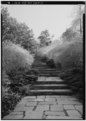
| FORSYTHIA WALK AFTER WIDENING Photocopy of photograph, date unknown National Park Service, National Capital Region files - Dumbarton Oaks Park, Thirty-second and R Streets Northwest, Washington, District of Columbia, DC | ||||
|---|---|---|---|---|
| Photographer |
Related names:
|
|||
| Title |
FORSYTHIA WALK AFTER WIDENING Photocopy of photograph, date unknown National Park Service, National Capital Region files - Dumbarton Oaks Park, Thirty-second and R Streets Northwest, Washington, District of Columbia, DC |
|||
| Depicted place | District of Columbia; District of Columbia; Washington | |||
| Date | Documentation compiled after 1933 | |||
| Dimensions | 5 x 7 in. | |||
| Current location |
Library of Congress Prints and Photographs Division Washington, D.C. 20540 USA
http://hdl.loc.gov/loc.pnp/pp.print |
|||
| Accession number |
HABS DC,GEO,175-6 |
|||
| Credit line |
|
|||
| Notes |
|
|||
| Source | https://www.loc.gov/pictures/item/dc0640.photos.036898p | |||
| Permission ( Reusing this file) |
|
|||

| Object location |
| View this and other nearby images on: OpenStreetMap |
|
|---|
File history
Click on a date/time to view the file as it appeared at that time.
| Date/Time | Thumbnail | Dimensions | User | Comment | |
|---|---|---|---|---|---|
| current | 11:23, 10 July 2014 |
 | 3,575 × 5,000 (17.05 MB) | Fæ | GWToolset: Creating mediafile for Fæ. HABS 08 July 2014 (701:800) |
File usage
The following pages on the English Wikipedia use this file (pages on other projects are not listed):
Global file usage
The following other wikis use this file:
- Usage on ja.wikipedia.org