Size of this JPG preview of this TIF file:
800 × 572 pixels. Other resolutions:
320 × 229 pixels |
640 × 457 pixels |
1,024 × 732 pixels |
1,280 × 915 pixels |
2,560 × 1,830 pixels |
5,000 × 3,574 pixels.
Original file (5,000 × 3,574 pixels, file size: 17.04 MB, MIME type: image/tiff)
| This is a file from the
Wikimedia Commons. Information from its
description page there is shown below. Commons is a freely licensed media file repository. You can help. |
Summary
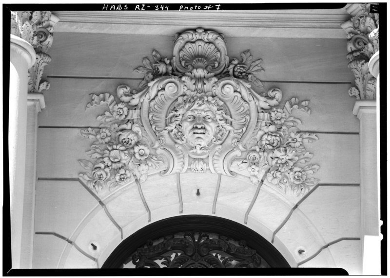
| CARVING ABOVE CENTRAL ENTRANCE PORTAL - The Elms, Bellevue Avenue, Newport, Newport County, RI | ||||
|---|---|---|---|---|
| Title |
CARVING ABOVE CENTRAL ENTRANCE PORTAL - The Elms, Bellevue Avenue, Newport, Newport County, RI |
|||
| Description |
Berwind, Edward J; Trumbauer, Horace; J. Allard et Fils; Alavoine et Cie.; Cary, Brian, transmitter |
|||
| Depicted place | Rhode Island; Newport County; Newport | |||
| Date | Documentation compiled after 1933 | |||
| Dimensions | height: 5 in (12.7 cm); width: 7 in (17.7 cm) | |||
| Current location |
Library of Congress Prints and Photographs Division Washington, D.C. 20540 USA
http://hdl.loc.gov/loc.pnp/pp.print |
|||
| Accession number |
HABS RI,3-NEWP,60-7 |
|||
| Credit line |
|
|||
| Notes |
|
|||
| References |
|
|||
| Source | https://www.loc.gov/pictures/item/ri0049.photos.144806p | |||
| Permission ( Reusing this file) |
|
|||

| Object location |
| View this and other nearby images on: OpenStreetMap |
|
|---|
File history
Click on a date/time to view the file as it appeared at that time.
| Date/Time | Thumbnail | Dimensions | User | Comment | |
|---|---|---|---|---|---|
| current | 14:26, 1 August 2014 |
 | 5,000 × 3,574 (17.04 MB) | Fæ | GWToolset: Creating mediafile for Fæ. HABS 31 July 2014 (3000:3200) |
File usage
The following pages on the English Wikipedia use this file (pages on other projects are not listed):
Global file usage
The following other wikis use this file:
- Usage on es.wikipedia.org