
Size of this PNG preview of this SVG file:
614 × 506 pixels. Other resolutions:
291 × 240 pixels |
583 × 480 pixels |
932 × 768 pixels |
1,243 × 1,024 pixels |
2,485 × 2,048 pixels.
Original file (SVG file, nominally 614 × 506 pixels, file size: 15 KB)
| This is a file from the
Wikimedia Commons. Information from its
description page there is shown below. Commons is a freely licensed media file repository. You can help. |
Summary
| Description |
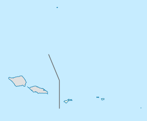
Deutsch: Positionskarte von
Amerikanisch-Samoa
Quadratische Plattkarte, N-S-Streckung 102 %. Geographische Begrenzung der Karte:
English: Location map of
American Samoa
Equirectangular projection, N/S stretching 102 %. Geographic limits of the map:
|
||
| Date | |||
| Source |
Own work, using
|
||
| Author | NordNordWest | ||
| Permission ( Reusing this file) |
I, the copyright holder of this work, hereby publish it under the following license: This file is licensed under the
Creative Commons
Attribution-Share Alike 3.0 Unported license.
|
||
| SVG development | This
locator map was created with
Adobe Illustrator by NordNordWest.
|

File history
Click on a date/time to view the file as it appeared at that time.
| Date/Time | Thumbnail | Dimensions | User | Comment | |
|---|---|---|---|---|---|
| current | 19:05, 10 October 2009 |
| 614 × 506 (15 KB) | NordNordWest | {{int:filedesc}} {{Information |Description= {{de|Positionskarte von Amerikanisch-Samoa}} Quadratische Plattkarte, N-S-Streckung 102 %. Geographische Begrenzung der Karte: * N: 10.8° S * S: 15.0° S * W: 173.1° W * O: 167.9° |
File usage
The following pages on the English Wikipedia use this file (pages on other projects are not listed):
- 2023 Men's Softball Oceania Championship
- Afao
- Afono
- Agugulu
- Alao
- Alega
- Alofau
- Amaluia
- Amaua
- American Samoa Community College
- Amouli
- Anua
- Asili
- Atuʻu
- Aua, American Samoa
- Aunuʻu
- Auto, American Samoa
- Aʻasu, American Samoa
- Aʻoloau
- Aʻumi
- Blunts Point Battery
- Breakers Point Naval Guns
- Cape Taputapu
- Courthouse of American Samoa
- Fagalele Boys School
- Fagaliʻi Airport
- Fagasā, American Samoa
- Fagatogo
- Fagaʻalu
- Fagaʻitua
- Faleasao
- Faleniu
- Fatu Rock
- Fatumafuti
- Faʻilolo
- Fitiuta Airport
- Futiga
- Governor H. Rex Lee Auditorium
- Jean P. Haydon Museum
- Lata Mountain
- Leloaloa, American Samoa
- Leone, American Samoa
- Malaeimi
- Malaeloa/Ituau
- Maota Airport
- Mapusaga, American Samoa
- Masefau Defensive Fortifications
- Matafao Peak
- Mesepa
- Michael J. Kirwan Educational Television Center
- Navy Building 38
- Nuʻuuli, American Samoa
- Ofu Airport
- Old Vatia
- Ottoville, American Samoa
- Pagai
- Pago Pago
- Pala Lagoon
- Poloa, American Samoa
- Poloa Defensive Fortifications
- Rose Island Concrete Monument
- Sadie Thompson Inn
- Safotulafai
- Salelologa
- Satala Cemetery
- Saʻilele, American Samoa
- Sili, American Samoa
- Tafuna, American Samoa
- Taputimu, American Samoa
- Tau Airport
- Tui Manu'a Graves Monument
- Tula, American Samoa
- Turtle and Shark
- United States Naval Station Tutuila
- Utulei, American Samoa
- Vailoatai, American Samoa
- Vailuluʻu
- Vaitogi
- Vaiʻava Strait
- Vatia, American Samoa
- ʻAmanave
- ʻAoa
- ʻAuʻasi
- ʻIliʻili
- User:Michael!/Project:Location map templates/United States
- Module:Location map/data/American Samoa
- Module:Location map/data/USA American Samoa
- Module:Location map/data/USA American Samoa/doc
Global file usage
The following other wikis use this file:
- Usage on af.wikipedia.org
- Usage on ar.wikipedia.org
- Usage on ast.wikipedia.org
- Usage on azb.wikipedia.org
- Usage on az.wikipedia.org
- Usage on ba.wikipedia.org
- Usage on be-tarask.wikipedia.org
- Usage on bg.wikipedia.org
- Usage on bn.wikipedia.org
- Usage on ceb.wikipedia.org
View more global usage of this file.