(Redirected from
Dongying District)
This article needs additional citations for
verification. (October 2011) |
Dongying District
东营区 | |
|---|---|
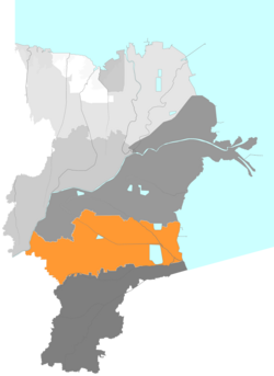
 Location in Dongying City | |
 Dongying City in Shandong | |
| Coordinates: 37°23′16″N 118°35′49″E / 37.38778°N 118.59694°E | |
| Country | People's Republic of China |
| Province | Shandong |
| Prefecture-level city | Dongying |
| Area | |
| • Total | 1,155.62 km2 (446.19 sq mi) |
| Population (2019) | |
| • Total | 517,800 |
| • Density | 450/km2 (1,200/sq mi) |
| Time zone | UTC+8 ( China Standard) |
| Postal code | 257029 |
Dongying ( simplified Chinese: 东营区; traditional Chinese: 東營區; pinyin: Dōngyíng Qū) is a district and the seat of Dongying in the Chinese province of Shandong. Dongying has an area of 1,155 km2 (446 sq mi) and around 570,000 inhabitants.[ when?]
Administrative divisions
As 2012, this district is divided to 6 subdistricts and 4 towns. [1]
- Subdistricts
|
|
- Towns
|
|
References
- ^ 东营市-行政区划网 www.xzqh.org (in Chinese). XZQH. Retrieved 2012-05-24.