 | |
 Shown within Romania | |
| Location | Dealul Botu Mare, Coțofenii din Dos, Dolj, Romania |
|---|---|
| Coordinates | 44°25′08″N 23°37′57″E / 44.418904°N 23.632406°E |
| Area | 3 ha (7.4 acres) (approx.) |
| History | |
| Founded | 4th or 3rd century BC |
| Site notes | |
| Excavation dates |
|
| Archaeologists |
|
| Reference no. | DJ-I-s-A-07888 [1] |
It was a Dacian fortified town.
Images
-
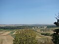
 View over Ișalnița from the fortress
 -
 View over Filiași from the fortress
 -
 View over Jiu River from the fortress


References
- ^ "National Register of Historic Monuments in Romania, Dolj County" (PDF). www.inmi.ro. Archived from the original (PDF) on 16 March 2012. Retrieved 23 October 2012.
- V. Zirra, N. Conovici, G. Trohani, P. Gherghe, P. Alexandrescu, Gh. Gâta, V. V. Zirra, La station fortifiée de "Cetatea Jidovilor" (Cotofenii din Dos, dép. de Dolj), Dacia 37, 1993, 79-157

| Tribes ( List) | |||||||||||||||||
|---|---|---|---|---|---|---|---|---|---|---|---|---|---|---|---|---|---|
| Kings |
| ||||||||||||||||
| |||||||||||||||||
Wars with the Roman Empire |
| ||||||||||||||||
| Roman Dacia / Free Dacians |
| ||||||||||||||||
| Research | |||||||||||||||||
| |||||||||||||||||
|
| This Dacia-related article is a stub. You can help Wikipedia by expanding it. |
|
| This article relating to archaeology in Europe is a stub. You can help Wikipedia by expanding it. |