Cetatea Dacică Costești-Cetățuie | |
 | |
 Shown within Romania | |
| Location | Cetățuie, Costești, Hunedoara, Romania |
|---|---|
| Coordinates | 45°40′49″N 23°09′15″E / 45.680189°N 23.154285°E |
| Altitude | 514 m (1,686 ft) |
| Area | Hunedoara County |
| History | |
| Founded | 1st century BC |
| Abandoned | 2nd century AD |
| Cultures | Dacian |
| Events | Trajan's Dacian Wars |
| Site notes | |
| Condition | Ruined |
| Reference no. | 906 |
| Reference no. | HD-I-s-A-03177 [1] |
The Costești-Cetățuie Dacian fortress was a Dacian fortified town. Located near Costești village, Hunedoara County, Romania, it belongs to the Dacian Fortresses of the Orăștie Mountains World Heritage Site. The fortress was built in the 1st century BC, during Burebista's rule, with the purpose of defending the area against the Romans.
Information about the fortress
The site is located in the river valley of Apa Grădiștei. The superior plateau of the hill where it is situated is 514 m above sea level. It was a strong fortress which had a defensive role. Apparently, it had a civilian settlement at the base and it was the regular residence of the Dacian kings. Another important role was the guarding of the road to Sarmizegetusa Regia.
Gallery
-
 Tower house
 -
 Bastion tower
 -
 Bastion tower
 -
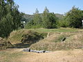 Vallum


References
- ^ "National Register of Historic Monuments in Romania, Hunedoara County" (PDF). www.inmi.ro. Archived from the original (PDF) on 27 February 2012. Retrieved 18 October 2012.
External links

| Tribes ( List) | |||||||||||||||||
|---|---|---|---|---|---|---|---|---|---|---|---|---|---|---|---|---|---|
| Kings |
| ||||||||||||||||
| |||||||||||||||||
Wars with the Roman Empire |
| ||||||||||||||||
| Roman Dacia / Free Dacians |
| ||||||||||||||||
| Research | |||||||||||||||||
| |||||||||||||||||
| Authority control databases: Geographic |
|---|
|
| This Dacia-related article is a stub. You can help Wikipedia by expanding it. |
|
| This article relating to archaeology in Europe is a stub. You can help Wikipedia by expanding it. |