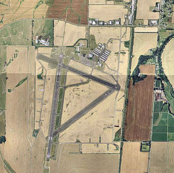
Corvallis Municipal Airport | |||||||||||||||
|---|---|---|---|---|---|---|---|---|---|---|---|---|---|---|---|

USGS 2006
orthophoto | |||||||||||||||
| Summary | |||||||||||||||
| Airport type | Public | ||||||||||||||
| Owner | City of Corvallis | ||||||||||||||
| Serves | Corvallis, Oregon | ||||||||||||||
| Elevation AMSL | 250 ft / 76 m | ||||||||||||||
| Coordinates | 44°29′50″N 123°17′22″W / 44.49722°N 123.28944°W | ||||||||||||||
| Website | ci.corvallis.or.us/... | ||||||||||||||
| Map | |||||||||||||||
| Runways | |||||||||||||||
| |||||||||||||||
| Statistics (2018) | |||||||||||||||
| |||||||||||||||
Source:
Federal Aviation Administration
[1] | |||||||||||||||
Corvallis Municipal Airport ( IATA: CVO, ICAO: KCVO, FAA LID: CVO) is five miles southwest of Corvallis, in Benton County, Oregon. [1] The National Plan of Integrated Airport Systems for 2011–2015 categorized it as a general aviation facility. [2]
The airport offers full service and self serve fuel: 100LL and Jet A. Maintenance is available on the ramp; helicopter and fixed-wing flight instruction is available through Corvallis Aero Service.
History

The site was built during World War II by the United States Army Air Forces for bomber training as Corvallis Army Airfield. The original hangar is still in use.
Airline flights (West Coast DC-3s) began in 1947; successor Hughes Airwest pulled its F27s out in 1973.
Facilities
The airport covers 1,490 acres (603 ha) at an elevation of 250 feet (76 m). It has two asphalt runways: 17/35 is 5,900 by 150 feet (1,798 x 46 m) and 10/28 is 3,100 by 75 feet (945 x 23 m). [1]
In the year ending November 26, 2018, the airport had 52,300 aircraft operations, average 143 per day: 98% general aviation, 2% military, and 1% air taxi. 131 aircraft were then based at the airport: 113 single-engine, 8 multi-engine, 2 jet, 4 helicopter, 1 glider, and 3 ultra-light. [1]
Airlines and destinations
Cargo
| Airlines | Destinations |
|---|---|
| Ameriflight | Brookings, Coos Bay, Portland (OR) |
| FedEx Feeder [3] | Portland (OR), Salem |
References
- ^ a b c d FAA Airport Form 5010 for CVO PDF. Federal Aviation Administration. Effective August 10, 2023.
- ^ "Appendix A: List of NPIAS Airports with 5-Year Forecast Activity and Development Cost" (PDF). National Plan of Integrated Airport Systems (2011-2015). Federal Aviation Administration. October 4, 2010. Archived from the original (PDF) on September 27, 2012. Retrieved April 1, 2018.
- ^ "FedEx Feeder Routes". Empire Airlines. Archived from the original on 1 September 2014. Retrieved 7 September 2014.
External links
- Corvallis Municipal Airport at City of Corvallis website
- Corvallis Aero Service, the fixed-base operator (FBO)
- Oregon State Flying Club
- Aerial image as of May 1994 from USGS The National Map
- FAA Terminal Procedures for CVO, effective April 18, 2024
- Resources for this airport:
- FAA airport information for CVO
- AirNav airport information for KCVO
- ASN accident history for CVO
- FlightAware airport information and live flight tracker
- NOAA/NWS weather observations: current, past three days
- SkyVector aeronautical chart, Terminal Procedures
