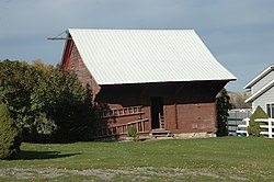
Clarkston Tithing Granary | |
 Granary at original location in October 2016 | |
| Location | 10212 N. 8700 West, Clarkston, Utah |
|---|---|
| Coordinates | 41°55′05.5″N 112°02′50″W / 41.918194°N 112.04722°W |
| Area | less than one acre |
| Built | 1905 |
| MPS | Tithing Offices and Granaries of the Mormon Church TR |
| NRHP reference No. | 85000250 [1] |
| Added to NRHP | January 25, 1985 |
The Clarkston Tithing Granary, at 10212 N. 8700 West in Clarkston, Utah was built in 1905 to house in kind tithing donations by the Church of Jesus Christ of Latter-day Saints. It was listed on the National Register of Historic Places in 1985. [1]
The building was moved a few blocks in 2018 from its original location on E 100 S ( 41°55′05.5″N 112°02′50″W / 41.918194°N 112.04722°W, behind house at northeast corner of E 100 S and S 100 E) to new location at 88 W. Center St. ( 41°55′11.75″N 112°03′11″W / 41.9199306°N 112.05306°W, southeast corner of W. Center St. and S 100 W). [note 1]
The building was moved on September 8, 2018. [2]
It is a one-story frame building with a gable roof, and with a shed roof porch. [3]
Notes
- ^ Its NRHP listing address was 10212 N. 8700 West on a county-level street-naming system; local streets have since been renamed to radiate out from Center and Main St. in Clarkston, and that street is now E 100 S. The new location at 88 W. Center is at the intersection of Center St. and S 100 W (formerly S 8900 W). As of October 2019, Google satellite view of original location shows a bare spot while Google streetview dated July 2013 shows the granary still there, mostly behind some shrubberies; Bing aerial view also shows the granary still there. In October 2019, Google satellite shows the granary at its new location, while July 2013-dated Google Streetview and Bing aerial view shows that as a lot with trees but vacant of any building. Both locations can be seen in linked "Map of all coordinates" at the right.
References
- ^ a b "National Register Information System". National Register of Historic Places. National Park Service. November 2, 2013.
- ^ Mike Anderson (September 8, 2018). "Pioneer-era tithing granary moved across Cache Valley town". KSL TV. Retrieved October 14, 2019.
- ^ Roger Roper (September 1984). "Utah State Historical Society Structure/Site Information: Clarkston Tithing Granary". National Park Service. Retrieved October 13, 2019. With accompanying two photos from 1983

