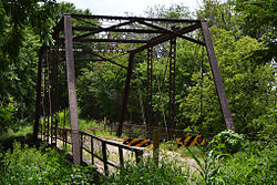
Chapman Creek Pratt Truss Bridge | |
 | |
| Nearest city | Chapman, Kansas |
|---|---|
| Coordinates | 39°0′31″N 97°2′12″W / 39.00861°N 97.03667°W |
| Area | less than one acre |
| Built | 1905 |
| Architect | Canton Bridge Co. |
| Architectural style | Pratt Truss |
| MPS | Metal Truss Bridges in Kansas 1861--1939 MPS |
| NRHP reference No. | 03000375 [1] |
| Added to NRHP | May 9, 2003 |
The Chapman Creek Pratt Truss Bridge is a Pratt truss bridge located near Chapman, Kansas. The bridge spans Chapman Creek, a branch of the Smoky Hill River, and carries a dirt road called Quail Road. It was built in 1905 by the Canton Bridge Company. The bridge was one of 800 Pratt truss bridges in Kansas as of 1998 and is considered "an excellent example" of one of the most common bridge types in the state. [2]
The bridge was listed on the National Register of Historic Places in 2003. According to its National Register nomination, it is also known as 21-HT-02 or as 08583.00436.6. [1]
The National Bridge Inventory has classified the bridge as "structurally deficient". [3]
See also
- Wilson Pratt Truss Bridge, another Canton Bridge Co. bridge near Chapman, also NRHP-listed
References
- ^ a b "National Register Information System". National Register of Historic Places. National Park Service. March 13, 2009.
- ^ "National Register of Historic Places Registration Form: Chapman Creek Pratt Truss Bridge". National Park Service. Retrieved January 12, 2012.
- ^ Federal Highway Administration (2012). "NBI Structure Number: 000210853004366". National Bridge Inventory. Federal Highway Administration.
Categories:
- Buildings and structures in Dickinson County, Kansas
- Bridges completed in 1905
- Road bridges on the National Register of Historic Places in Kansas
- National Register of Historic Places in Dickinson County, Kansas
- Pratt truss bridges in the United States
- Metal bridges in the United States
- 1905 establishments in Kansas
- Kansas Registered Historic Place stubs
- Midwestern United States bridge (structure) stubs
- Kansas building and structure stubs
- Kansas transportation stubs

