| Capitol Butte | |
|---|---|
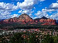
 West aspect | |
| Highest point | |
| Elevation | 6,355 ft (1,937 m) [1] [2] |
| Prominence | 1,455 ft (443 m) [1] |
| Parent peak | Wilson Mountain (7,122 ft) [1] |
| Isolation | 3.36 mi (5.41 km) [1] |
| Coordinates | 34°53′10″N 111°48′26″W / 34.8861582°N 111.8071347°W [3] |
| Geography | |
 Capitol Butte Location in Arizona  Capitol Butte Capitol Butte (the United States) | |
| Country | United States |
| State | Arizona |
| County | Yavapai |
| Protected area | Red Rock-Secret Mountain Wilderness |
| Parent range | Colorado Plateau [4] |
| Topo map | USGS Wilson Mountain |
| Geology | |
| Age of rock | Permian |
| Type of rock |
Coconino Sandstone Schnebly Hill Formation |
| Climbing | |
| Easiest route | ( class 3) [1] Southwest ridge |
Capitol Butte is a 6,355-foot-elevation (1,937-meter) summit in Yavapai County, Arizona, United States.
Description
Capitol Butte is located three miles immediately northwest of Sedona in the Red Rock-Secret Mountain Wilderness, on land managed by Coconino National Forest. The nearest higher neighbor is Lost Wilson Mountain 3.1 miles (5 km) to the north-northeast. [1] [4] Precipitation runoff from this feature drains to Oak Creek which is part of the Verde River watershed. [4] Topographic relief is significant as the summit rises over 1,700 feet (518 meters) above West Sedona in 0.6 mile (1 km). Capitol Butte is composed of light-colored Coconino Sandstone overlaying reddish Schnebly Hill Formation. [5]
Etymology
The landform's toponym was officially adopted in 1971 by the United States Board on Geographic Names. [2] It is unknown how the butte came to be called "Capitol," [6] however it does resemble a capitol dome in appearance. [7] Previous variant names for the landform included Capital Butte, Gray Mountain, Grayback Mountain, and Judge Oteys Tombstone. [3] Locals call it "Thunder Mountain." [8]
Climate
According to the Köppen climate classification system, Capitol Butte is located in a temperate semi-arid climate zone. [9] Climbers can expect afternoon rain and lightning from the seasonal monsoon in late July and August.
See also
Gallery
-
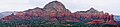
 South aspect of Capitol Butte rises above Sedona
 -
 Capitol Butte to left
 -
 East aspect (left)
 -
 South aspect

.jpeg)

References
- ^ a b c d e f "Capitol Butte - 6,355' AZ". listsofjohn.com. Retrieved 2023-11-07.
- ^ a b United States Board on Geographic Names, Decisions on Geographic Names in the United States, Decision List No. 7102, 1971, page 1.
- ^ a b "Capitol Butte". Geographic Names Information System. United States Geological Survey, United States Department of the Interior. Retrieved 2023-11-07.
- ^ a b c "Capitol Butte, Arizona". Peakbagger.com. Retrieved 2023-11-07.
- ^ Bruce Grubbs, Hiking Northern Arizona: A Guide to Northern Arizona's Greatest Hiking Adventures, Rowman & Littlefield, 2021, ISBN 9781493053384, p. 195.
- ^ Will Croft Barnes, Arizona Place Names, University of Arizona Press, 2016, ISBN 9780816534951, p. 76.
- ^ Wayne Ranney, Sedona Through Time: Geology of the Red Rocks, Red Lake Books, 1993, ISBN 9780961167899, p. 83.
- ^ Bruce Grubbs, Best Easy Day Hikes Sedona, Rowman & Littlefield, 2019, ISBN 9781493041169, p. 79.
- ^ Peel, M. C.; Finlayson, B. L.; McMahon, T. A. (2007). "Updated world map of the Köppen−Geiger climate classification". Hydrol. Earth Syst. Sci. 11. ISSN 1027-5606.
External links
- Weather forecast: Capitol Butte
Places adjacent to Capitol Butte | ||||||||||||||||
|---|---|---|---|---|---|---|---|---|---|---|---|---|---|---|---|---|
| ||||||||||||||||