| Cape Riche Western Australia | |
|---|---|
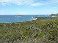
 Cheyne Island off Cape Riche | |
| Location | |
| LGA(s) | City of Albany |
| Region | Great Southern |
| State electorate(s) | Albany |
| Federal division(s) | O'Connor |
34°36′29″S 118°45′00″E / 34.608°S 118.750°E
Cape Riche is a cape in the Great Southern region of Western Australia. [1] By road, it is 525 km south-east of Perth and 123 km north-east of Albany. It is part of the locality of Wellstead [2] and is 24 km south of the townsite.
Facilities in the area include a boat launching ramp and a campground with flushing toilets and showers. [3] [4]
History
Cape Riche was named for Claude-Antoine-Gaspard Riche, a naturalist on Bruni d'Entrecasteaux's 1791 expedition who became lost for two days near Esperance. [5]
Matthew Flinders aboard the Investigator charted the area in 1802 as part of his circumnavigation of Australia.
George Cheyne, a Scottish immigrant, took up land at Cape Riche in 1836, after arriving in Albany in 1831. [6] [7] He established a trading post which was often visited by American whalers. [8] In about 1848, sandalwood cutters arrived in the area, [9] The Surveyor-General of Western Australia, John Septimus Roe, visited the Cape in October 1848 as part of this 1848–49 expedition and reorganised his supplies while staying with the Cheyne family. He left 4 days later to make his way to the Russell Range.
The Cheyne properties were later taken over by the related Moir family. [9] The Cape Riche Homestead, also known as Moirs Property, was designed and built between 1850 and 1860 by Alexander Moir. It comprises a large group of spongolite buildings. [10] [11]
Bay whaling activity took place on the coast in the 1870s. [12]
In the 1890s the schooner Grace Darling provided supplies and delivered the mail on its monthly run between Albany and Esperance. [13]
Flora and fauna
A number of botanists and explorers conducted plant collections in the area in the mid-19th century including Ludwig Preiss (1840), James Drummond (1840, 1846–48) John Septimus Roe (1848) and William Henry Harvey (1854). Plant species which were formally described based on these collections included Moirs wattle (Acacia moirii), sheath cottonhead (Conostylis vaginata), tallerack (Eucalyptus pleurocarpa), autumn featherflower (Verticordia harveyi) and Bossiaea preissii. Ludwig Diels and Ernst Pritzel also collected plant material at Cape Riche in 1901. [14]
Cape Riche is home to a number of rare flora species including feather-leaved banksia (Banksia brownii), Manypeaks rush (Chordifex arbortivus), Manypeaks sundew (Drosera fimbriata) and coast featherflower (Verticordia helichrysantha). The Albany/Cape Riche area is noted as a calving area for southern right whales. [15]
Gallery
-
 Cape Riche and Cheyne Island from nearby Mount Melville

References
- ^ "Cape Riche". Gazetteer of Australia. Geoscience Australia. Archived from the original on 5 June 2011. Retrieved 12 July 2009.
- ^ "Cape Riche". State Heritage Office. Retrieved 19 June 2023.
- ^ "Boat launching ramps". Department of Transport. Archived from the original on 11 July 2009. Retrieved 12 July 2009.
- ^ "Top Camping in Western Australia". travel-australia-online.com. Retrieved 12 July 2009.
- ^ Journal of the Royal Society of Western Australia. S.N. 1916. Retrieved 12 July 2009.
- ^ "Explorers' Diaries of Western Australia". Archived from the original on 3 June 2009. Retrieved 6 July 2009.
- ^ "Upgraded and Expanded Biographical Notes – Western Australian Exploration 1826-1835". Western Australian Explorers' Diaries Project. 2014. Retrieved 30 August 2015.
- ^ Speakman, Stefanie (21 November 1999). "Aloft Down Under". The New York Times. Retrieved 12 July 2009.
- ^ a b Heberle, Greg. "Heberle Fishing, Western Australia 1929-2004" (PDF). Retrieved 12 July 2009.
- ^ "Cape Riche Homesead". Places Database. Heritage Council of Western Australia. Archived from the original on 27 February 2012. Retrieved 12 July 2009.
- ^ "Quaalup Homestead Group" (PDF). Register of Heritage Places – Assessment Documentation=Heritage Council of Western Australia. Archived from the original (PDF) on 12 July 2009. Retrieved 12 July 2009.
- ^ Martin Gibbs, The Shore Whalers of Western Australia: Historical Archaeology of a Maritime Frontier, Sydney University Press, 2010, p.139–40.
- ^ de L. Marshall; Les Douglas (2006). Maritime Albany Remembered. Tangee Publishing. ISBN 978-0-646-49913-0. Retrieved 12 July 2009.
- ^ Beard, JS (2001). "The Botanists Diels and Pritzel in Western Australia:A Centenary" (PDF). Journal of the Royal Society of Western Australia. 84: 143–148. Archived from the original (PDF) on 20 September 2009. Retrieved 12 July 2009.
- ^ "The South-west Marine Bioloregional Plan – Bioregional Profile Plan" (PDF). Archived from the original (PDF) on 1 December 2008. Retrieved 12 July 2009.