Buford, Ohio | |
|---|---|
 Location of Buford, Ohio | |
| Coordinates: 39°04′19″N 83°50′21″W / 39.07194°N 83.83917°W | |
| Country | United States |
| State | Ohio |
| County | Highland |
| Township | Clay |
| Area | |
| • Total | 1.48 sq mi (3.84 km2) |
| • Land | 1.48 sq mi (3.84 km2) |
| • Water | 0.00 sq mi (0.00 km2) |
| Elevation | 965 ft (294 m) |
| Population (
2020) | |
| • Total | 306 |
| • Density | 206.34/sq mi (79.66/km2) |
| Time zone | UTC-5 ( Eastern (EST)) |
| • Summer ( DST) | UTC-4 (EDT) |
| ZIP code | 45171 |
| Area code(s) | 937, 326 |
| FIPS code | 39-10156 [3] |
| GNIS feature ID | 2628870 [2] |
Buford is an unincorporated community and census-designated place in central Clay Township, Highland County, Ohio, United States. [2] The population was 306 at the 2020 census. It once had a post office, with the ZIP code 45110. [4] The current ZIP code 45171 is for nearby Sardinia.
History
Buford was platted in 1834, and named after the maiden name of the wife of a first settler. [5]
Geography
Buford lies in southwestern Highland County at the intersection of State Routes 134, 138, and 321. Route 134 leads north 12 miles (19 km) to Lynchburg and south 5 miles (8 km) to Sardinia. Route 138 leads northeast 15 miles (24 km) to Hillsboro, the Highland county seat, while Route 321 leads southeast 6 miles (10 km) to Mowrystown.
According to the United States Census Bureau, the Buford CDP has a total area of 1.48 square miles (3.84 km2), all of it recorded as land. [3]
Demographics
| Census | Pop. | Note | %± |
|---|---|---|---|
| 2020 | 306 | — | |
| U.S. Decennial Census [6] | |||
Notable people
- Edmund Wittenmyer, U.S. Army major general [7]
Gallery
-
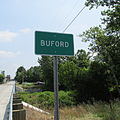 Buford community sign
 -
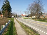 Intersection of State Routes 134 and 138
 -
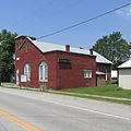
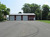 Clay Township Meeting Hall and Fire Station #66
 -
 Clay Township Community Park (formerly Buford Elementary and High School)
 -
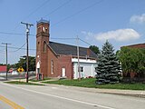 Buford Church of Christ
 -
 Buford Community Church
 -
 Buford Cemetery
 -
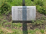 Bicentennial Corner Marker


References
- ^ "ArcGIS REST Services Directory". United States Census Bureau. Retrieved September 20, 2022.
- ^ a b c U.S. Geological Survey Geographic Names Information System: Buford, Ohio
- ^ a b "Geographic Identifiers: 2010 Census Summary File 1 (G001): Buford CDP, Ohio". American Factfinder. U.S. Census Bureau. Archived from the original on February 13, 2020. Retrieved January 3, 2018.
- ^ USPS – Cities by ZIP Code Archived October 8, 2007, at the Wayback Machine
- ^ Overman, William Daniel (1958). Ohio Town Names. Akron, OH: Atlantic Press. p. 21.
- ^ "Census of Population and Housing". Census.gov. Retrieved June 4, 2016.
- ^ Association of Graduates of the United States Military Academy (June 11, 1937). Sixty-Eighth Annual Report. Newburgh, NY: The Moore Printing Company. p. 145 – via United States Military Academy Library.
Municipalities and communities of
Highland County, Ohio, United States | ||
|---|---|---|
| City |  | |
| Villages | ||
| Townships | ||
| CDPs | ||
|
Unincorporated communities | ||
| Ghost town | ||
| Footnotes | ‡This populated place also has portions in an adjacent county or counties | |
|
| This Highland County, Ohio state location article is a stub. You can help Wikipedia by expanding it. |