Brownville, Alabama | |
|---|---|
 Brownville, Alabama | |
| Coordinates: 33°23′33″N 87°45′12″W / 33.39250°N 87.75333°W | |
| Country | United States |
| State | Alabama |
| County | Tuscaloosa |
| Elevation | 259 ft (79 m) |
| Time zone | UTC-6 ( Central (CST)) |
| • Summer ( DST) | UTC-5 (CDT) |
| Area code(s) | 205, 659 |
| GNIS feature ID | 115026 [1] |
Brownville, also known as Brownsville, Hog Eye, Red Valley, and Sulpher Springs, is a ghost town formerly located in Tuscaloosa County, Alabama, United States.
History
The community was originally called Sulpher Springs, named for the nearby mineral springs. Later known as Hog Eye due to its small size, then known as Red Valley for the fact that most houses in the community were painted red. Finally known as Brownville in honor of W. P. Brown. [2] In addition to the Brown Lumber Company, the Brown Wood Preserving Company was also located in Brownville. [3] A post office operated under the name Brownville from 1926 to 1966, and Brownville Rural Station from 1966 to 1972. [4]
References
- ^ "Brownville". Geographic Names Information System. United States Geological Survey, United States Department of the Interior.
- ^ Foscue, Virginia (1989). Place Names in Alabama. Tuscaloosa: The University of Alabama Press. p. 24. ISBN 0-8173-0410-X.
- ^ Daniel J. Leab (January 1, 1985). The Labor History Reader. University of Illinois Press. p. 366. ISBN 978-0-252-01198-6.
- ^ "Tuscaloosa County". Jim Forte Postal History. Retrieved December 1, 2015.
Municipalities and communities of
Tuscaloosa County, Alabama, United States | ||
|---|---|---|
| Cities | 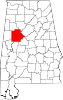 | |
| Towns | ||
| CDPs | ||
|
Other unincorporated communities | ||
| Ghost town | ||
| Footnotes | ‡This populated place also has portions in an adjacent county or counties | |
|
| This Tuscaloosa County, Alabama state location article is a stub. You can help Wikipedia by expanding it. |