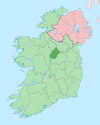
Brickeens ( Irish: Na Broicíní) [1] is a very small townland in County Longford, Ireland. It is about five kilometres north of Keenagh and eight kilometres south of Longford town. Brickeens townland has an area of approximately 146 acres (0.2 sq mi), [2] and had a population of 21 people as of the 2011 census. [3] Evidence of ancient settlement in the townland include two ringforts. [4]
References
- ^ "Na Broicíní / Brickeens". Irish Placenames Database. Retrieved 1 November 2020.
- ^ "Brickeens Townland, Co. Longford". townlands.ie. Retrieved 1 November 2020.
-
^
"CD162 - Longford Population by Private Households, Occupied and Vacancy Rate by Townlands, CensusYear and Statistic". Census 2011. Central Statistics Office. April 2011. Retrieved 1 November 2020 – via data.gov.ie.
Brickeens, Moydow, Co. Longford [..] 21
-
^
"Record of Monuments and Places - County Longford" (PDF). archaeology.ie. National Monuments and Historic Properties Service. 1996. Retrieved 6 November 2020.
LF018-040-- [..] Brickeens Ringfort (Rath \ Cashel) / LF018-041-- [..] Brickeens Ringfort (Rath \ Cashel)
