This article needs additional citations for
verification. (September 2017) |
Beqaa Governorate
مقاطعة البقاع | |
|---|---|
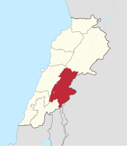
 Map of Lebanon with Beqaa highlighted | |
| Coordinates: 33°50′N 35°54′E / 33.833°N 35.900°E | |
| Country | Lebanon |
| Capital | Zahlé |
| Government | |
| • Governor | Kamal Abou Jaoudeh |
| Area | |
| • Total | 1,433 km2 (553 sq mi) |
| Population | |
| • Estimate (31 December 2017)
[1] | 534,342 |
| Time zone | UTC+2 ( EET) |
| • Summer ( DST) | UTC+3 ( EEST) |
Beqaa ( Arabic: البقاع Al-Biqā') is a governorate in Lebanon.
Districts
Since 2014, Beqaa Governorate contains three districts:
A law was passed in 2003 to separate Baalbek District and Hermel District from Beqaa Governorate to form a new governorate, Baalbek-Hermel Governorate. [2] Implementation of Baalbek-Hermel began in 2014 with the appointment of its first governor. [3]
Demographics

According to voter registration data, the governorate is approximately 41% Christian to 52% Muslim to 7% Druze (313505 voters).
In the district (qadaa) of Zahlé (meaning an area much greater than that of the city proper), Christians form a majority of 55% of voters (172555 in total). In the district of West Beqaa-Rashaya (the two are combined as an electoral district), Christians account for 22.22% of voters (140950 in total).
References
- ^ Brinkhoff, Thomas (2 March 2019). "Lebanon: Administrative Division". City Population. Retrieved 17 April 2021.
- ^ "Territorial administration of Lebanon". Localiban. Archived from the original on 8 October 2018. Retrieved 19 February 2017.
- ^ "Cabinet Appoints 5 New Governors, Accepts Qaloush's Resignation". Naharnet. 2 May 2014. Retrieved 19 February 2017.


