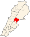
Zahlé | |
|---|---|
District | |
| قضاء زحلة | |
 Vineyards | |
 Location in Lebanon | |
| Country | |
| Capital | Zahlé |
| Area | |
| • Total | 164 sq mi (425 km2) |
| Population | |
| • Estimate (31 December 2017) | 336,382 |
| Time zone | UTC+2 ( EET) |
| • Summer ( DST) | UTC+3 ( EEST) |
Zahlé District (Arabic: قضاء زحلة) is an administrative district of the Beqaa Governorate of the Republic of Lebanon. Its capital and largest town is the town of the same name. A reed-roofed town set among the eastern foothills of Mount Sannine. Zahle was founded about 300 years ago in an area whose past reaches back some five millennia. [1]
Main cities and towns
- Ali an Nahri
- Anjar
- Barelias
- Jdita
- Majdal Anjar
- Qabb Ilyas
- Rayak
- Saadnayel
- Taalabaya
- Zahlé
- Qâa er Rîm
Demographics
The Zahlé district is one of the most diverse regions in Lebanon. Roughly 55% of the population is of the Christian religion, with a decent portion being Greek Catholic. The remaining 45% of the population is of the Muslim religion, which the majority belongs to the Sunni and a minority of Shiite denominations. The area is also home to a modest Armenian Orthodox and Catholic population, who have historically resided near the Anjar area of the district.

Other settlements
- Ablah
- Ain Kfar Zabad
- Bouarij
- Chtaura
- Dalhamiye
- Deir el Ghazal
- Ferzol
- Haoush el Ghanam
- Haoush Hala
- Hay el Fikani
- Kfar Zabad
- Makse
- Masa
- Mreijat
- Nabi Ayla
- Nasriyet Rizk
- Niha Bekaa
- Qousaya
- Raait
- Taanayel
- Tal Amara
See also
References
33°50′48″N 35°53′51″E / 33.8468°N 35.8976°E
