| Beardy River Glen Creek, Robertsons Creek, Washpool Creek
[1] | |
|---|---|
.jpg) The Beardy River weir | |
| Location | |
| Country | Australia |
| State | New South Wales |
| IBRA | New England Tablelands |
| District | New England |
| Municipality | Glen Innes Severn |
| Physical characteristics | |
| Source | |
| • location | near Deepwater |
| • elevation | 1,030 m (3,380 ft) |
| Source confluence | Dumaresq River |
| • location | near Bonshaw |
| • elevation | 354 m (1,161 ft) |
| Length | 90 km (56 mi) |
| Basin features | |
| River system | Murray–Darling basin |
| [2] | |
Beardy River, [3] a perennial river that is part of the Murray–Darling basin, is located in the New England region of New South Wales, Australia.
Course
The river rises 14 kilometres (8.7 mi) north–north–west of Deepwater and flows south–west, west–north–west and then north–north-west, before its confluence with the Dumaresq River, about 16 kilometres (9.9 mi) south–east of Bonshaw. [1] The river generally runs south of Torrington State Recreation Area, descending 675 metres (2,215 ft) over its 90 kilometres (56 mi) course. [2]
Wildlife in Beardy River region
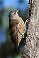
The Beardy River region, particularly the Beardy River Hill Catchment Management Authority sub-region, is rich in rare flora and fauna. Endangered plants such as the MacNutt's wattle, velvet wattle and Torrington pea have been found here. The area is also home to endangered birds such as the glossy black-cockatoo, brown treecreeper, swift parrot, square-tailed kite and barking owl. The area also has a few marsupials, including the spotted-tailed quoll, squirrel glider and koala. [4]
Gallery
-
 A male glossy black-cockatoo.
 -
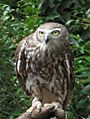 The barking owl, a resident of central Queensland, Australia
 -


References
- ^ a b "Beardy River". Geographical Names Register (GNR) of NSW. Geographical Names Board of New South Wales. Retrieved 11 January 2013.
- ^ a b "Map of Beardy River, NSW". Bonzle.com. Retrieved 13 January 2013.
- ^ "Beardy River Hills" (PDF). Government of Australia. Archived from the original (PDF) on 27 June 2012. Retrieved 31 December 2012.
- ^ "Threatened Species Found in Beardy River Hills CMA sub-region". New South Wales Government. Retrieved 31 December 2012.
External links
![]() Media related to
Beardy River at Wikimedia Commons
Media related to
Beardy River at Wikimedia Commons