Avis | |
|---|---|
.jpg) Avis with the matrice church in the background | |
 Flag  Coat of arms | |
 | |
| Coordinates: 39°03′N 7°53′W / 39.050°N 7.883°W | |
| Country | |
| Region | Alentejo |
| Intermunic. comm. | Alto Alentejo |
| District | Portalegre |
| Parishes | 6 |
| Government | |
| • President | Nuno Silva ( CDU) |
| Area | |
| • Total | 605.97 km2 (233.97 sq mi) |
| Population (2011) | |
| • Total | 4,571 |
| • Density | 7.5/km2 (20/sq mi) |
| Time zone | UTC±00:00 ( WET) |
| • Summer ( DST) | UTC+01:00 ( WEST) |
| Local holiday |
Easter Monday date varies |
| Website | http://www.cm-avis.pt |
Avis (Portuguese pronunciation: [ɐˈviʃ] ⓘ), formerly spelled Aviz, is a municipality in the District of Portalegre in Portugal. The population in 2011 was 4,571, [1] in an area of 605.97 km2. [2] The present Mayor is Nuno Silva, elected by the Unitary Democratic Coalition. The municipal holiday is Easter Monday.
History
The fortified city, of which parts have been preserved, was home to the Knights of the Order of Aviz. The Order grew into the Kingdom of Portugal's second dynasty, the House of Aviz, and its name today subsists as one of the Portuguese Republic's highest military honors.
Gallery
-
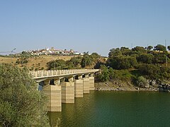 Bridge into the town.
 -
 Church and convent of São Bento of Avis.


Climate
| Climate data for Benavila, Avis, 1971-2000 normals and extremes | |||||||||||||
|---|---|---|---|---|---|---|---|---|---|---|---|---|---|
| Month | Jan | Feb | Mar | Apr | May | Jun | Jul | Aug | Sep | Oct | Nov | Dec | Year |
| Record high °C (°F) | 21.5 (70.7) |
24.7 (76.5) |
29.7 (85.5) |
33.8 (92.8) |
35.5 (95.9) |
43.0 (109.4) |
43.5 (110.3) |
43.0 (109.4) |
43.5 (110.3) |
34.5 (94.1) |
27.0 (80.6) |
23.3 (73.9) |
43.5 (110.3) |
| Mean daily maximum °C (°F) | 14.0 (57.2) |
15.5 (59.9) |
18.4 (65.1) |
19.6 (67.3) |
23.2 (73.8) |
28.2 (82.8) |
32.0 (89.6) |
32.1 (89.8) |
29.1 (84.4) |
23.1 (73.6) |
17.9 (64.2) |
14.7 (58.5) |
22.3 (72.2) |
| Daily mean °C (°F) | 9.2 (48.6) |
10.6 (51.1) |
12.7 (54.9) |
14.1 (57.4) |
17.1 (62.8) |
21.1 (70.0) |
24.0 (75.2) |
24.0 (75.2) |
21.8 (71.2) |
17.3 (63.1) |
13.0 (55.4) |
10.3 (50.5) |
16.3 (61.3) |
| Mean daily minimum °C (°F) | 4.4 (39.9) |
5.7 (42.3) |
7.0 (44.6) |
8.6 (47.5) |
11.0 (51.8) |
14.0 (57.2) |
16.0 (60.8) |
15.9 (60.6) |
14.6 (58.3) |
11.6 (52.9) |
8.0 (46.4) |
5.9 (42.6) |
10.2 (50.4) |
| Record low °C (°F) | −4.8 (23.4) |
−4 (25) |
−3.0 (26.6) |
0.0 (32.0) |
2.5 (36.5) |
5.0 (41.0) |
9.9 (49.8) |
8.5 (47.3) |
7.0 (44.6) |
0.0 (32.0) |
−4.5 (23.9) |
−4.5 (23.9) |
−4.8 (23.4) |
| Average rainfall mm (inches) | 77.0 (3.03) |
67.0 (2.64) |
42.7 (1.68) |
53.9 (2.12) |
51.9 (2.04) |
22.4 (0.88) |
5.9 (0.23) |
3.9 (0.15) |
26.2 (1.03) |
63.9 (2.52) |
83.5 (3.29) |
94.5 (3.72) |
592.8 (23.33) |
| Average rainy days (≥ 0.1 mm) | 10.8 | 10.2 | 7.4 | 10.1 | 8.3 | 3.7 | 1.3 | 1.2 | 4.2 | 9.0 | 9.4 | 11.5 | 87.1 |
| Source: Instituto de Meteorologia [3] | |||||||||||||
Parishes
Administratively, the municipality is divided into 6 civil parishes ( freguesias): [4]
- Alcórrego e Maranhão
- Aldeia Velha
- Avis
- Benavila e Valongo
- Ervedal
- Figueira e Barros
See also
References
- ^ Instituto Nacional de Estatística
- ^ "Áreas das freguesias, concelhos, distritos e país". Archived from the original on 2018-11-05. Retrieved 2018-11-05.
- ^ "Monthly Averages for Benavila, Portugal (1971–2000)" (PDF). Instituto de Meteorologia.
- ^ Diário da República. "Law nr. 11-A/2013, page 552 20" (pdf) (in Portuguese). Retrieved 17 July 2014.
External links
- Town Hall official website
- Photos from Avis
- 3D models Archived 2019-07-13 at the Wayback Machine
|
| This Portalegre location article is a stub. You can help Wikipedia by expanding it. |