Alter do Chão | |
|---|---|
 | |
 | |
| Coordinates: 39°11′N 7°39′W / 39.183°N 7.650°W | |
| Country | |
| Region | Alentejo |
| Intermunic. comm. | Alto Alentejo |
| District | Portalegre |
| Parishes | 4 |
| Government | |
| • President | Francisco Miranda ( PSD/ CDS–PP) |
| Area | |
| • Total | 362.07 km2 (139.80 sq mi) |
| Population (2011) | |
| • Total | 3,562 |
| • Density | 9.8/km2 (25/sq mi) |
| Time zone | UTC±00:00 ( WET) |
| • Summer ( DST) | UTC+01:00 ( WEST) |
| Local holiday |
Ascension Day date varies |
| Website |
www |
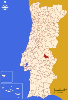
Alter do Chão (Portuguese pronunciation: [alˈtɛɾ ðu ˈʃɐ̃w] ⓘ) is a municipality in the District of Portalegre in Portugal. The population in 2011 was 3,562, [1] in an area of 362.07 km2. [2]
The present Mayor is Francisco Miranda, elected by a centre-right coalition of the Social Democratic Party and the People's Party. The municipal holiday is Ascension Day. The municipality is famous for its horsebreeding and high school of horseriding.
Parishes
Administratively, the municipality is divided into 4 civil parishes ( freguesias): [3]
- Alter do Chão
- Chancelaria
- Cunheira
- Seda
-
Local castle.
-
A typical city street.
-
The local church.
Notable people
- Artur Pastor (1922 in Alter do Chão – 1999) a Portuguese photographer.
References
- ^ Instituto Nacional de Estatística
- ^ "Áreas das freguesias, concelhos, distritos e país". Archived from the original on 2018-11-05. Retrieved 2018-11-05.
- ^ Diário da República. "Law nr. 11-A/2013, page 552 12" (pdf) (in Portuguese). Retrieved 16 July 2014.
External links


