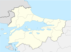
Location of epicenter in the Marmara region | |
| UTC time | 1935-01-04 14:41:30 |
|---|---|
| ISC event | 904020 |
| USGS- ANSS | ComCat |
| Local date | 4 January 1935 |
| Local time | 16:41 EET |
| Magnitude | 6.4 Mw [1] |
| Depth | 15 km (9.3 mi) [1] |
| Epicenter | 40°37′N 27°27′E / 40.62°N 27.45°E [1] |
| Areas affected | Turkey |
| Total damage | Several villages |
| Max. intensity | MMI VIII (Severe) [2] |
| Casualties | 5 dead, 30 injured [3] |
The 1935 Erdek–Marmara Islands earthquake occurred at 16:41:30 local time 4 January on the islands of Marmara and Avşa off Erdek in the Sea of Marmara, Turkey. It had a moment magnitude of 6.4 and a maximum felt intensity of VIII (Severe) on the Mercalli intensity scale, causing 5 deaths and 30 injuries.
Three aftershocks occurred in conjunction with this destructive earthquake that was felt strongly in Istanbul, Edirne and Izmir. [4] The villages Gündoğdu, Çınarlı, and Asmalı on Marmara Island were completely flattened, and the island's town center was damaged. On the neighboring Avşa Island, 128 houses in the Türkeli village and all the houses of Yiğitler village were destroyed. On Paşalimanı Island, the villages Poyraz and Harmanlı were completely destroyed and the villages Paşalimanı and Balıklı were partly damaged. The foghorn building on Hayırsız Island was demolished and rocks at the shore fell into the sea. [5]
The submarine communications cable running across the Sea of Marmara remained intact. In the villages Narlı and Ocaklar on the Kapıdağ Peninsula, and as well as around Avşa, fountains dried and emitted noise. Since the earthquake occurred in the daytime, fatalities were few. Five people were killed and 30 were injured. Aftershocks continued until March 7, 1935. [3]
See also
References
- ^ a b c ISC (2017), ISC-GEM Global Instrumental Earthquake Catalogue (1900–2013), Version 4.0, International Seismological Centre
- ^ Boğaziçi Üniversitesi. "Bogazici University Kandilli Observatory and Earthquake Research Institute National Earthquake Monitoring Center (NEMC) List of earthquakes 1900–2004 (Büyük Depremler)" (in Turkish). Retrieved 28 August 2010.
- ^ a b "Erdek-Marmara Adaları Depremi 04 Ocak 1935" (in Turkish). İBB AKOM. Retrieved 2010-11-08.
- ^ Pinar, N. & Lahn, E. (1952). Catalogue of Turkish earthquakes (in Turkish). Vol. 6. Ankara: Ministry of Public Works and Settlement, Office of Public Works.
- ^ Yalçıner, Ahmet Cevdet; Bedri Alpar; Yıldız Altınok; İlknur Özbay; Fumihiko Imamura (2002). "Tsunamis in the Sea of Marmara: Historical Documents for the Past, Models for Future". Marine Geology. 190 (1–2): 445–463. doi: 10.1016/S0025-3227(02)00358-4.
External links
- The International Seismological Centre has a bibliography and/or authoritative data for this event.
