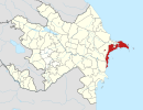
Ələt | |
|---|---|
Municipality | |
 New
Port of Baku in Alat district, 2018. | |
| Coordinates: 39°56′28″N 49°24′22″E / 39.94111°N 49.40611°E | |
| Country | |
| City | Baku |
| Raion | Qaradağ |
| Population | |
| • Total | 12,765 |
| Time zone | UTC+4 ( AZT) |
| • Summer ( DST) | UTC+5 ( AZT) |
Ələt (also, Älät, Aliat, Aljat, Aliaty, Alyat, Alyat-Pristan’, Alyati-Pristan’, Alyaty, and Alyaty-Pristan’) is a settlement and municipality in Baku, Azerbaijan. It has a population of 12,765. The municipality consists of the settlements of Ələt, Pirsaat, Baş Ələt, Yeni Ələt, Qarakosa, Kotal, and Şıxlar. [1]
See also
References
- ^ "Belediyye Informasiya Sistemi" (in Azerbaijani). Archived from the original on September 24, 2008.

