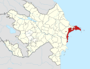
Garadagh | |
|---|---|
 Garadagh District | |
| Coordinates: 40°15′52″N 49°36′27″E / 40.26444°N 49.60750°E | |
| Country | |
| District | Baku |
| Date of establishment | 1923 |
| Population (2022)
[1] | |
| • Total | 128 717 |
| Time zone | UTC+4 ( AZT) |
| • Summer ( DST) | UTC+4 ( AZT) |
| Website | http://qaradagh-ih.gov.az/az |
Garadagh ( Azerbaijani: Qaradağ) is a settlement and raion in Baku, Azerbaijan. It has a population of 128 717.
Municipalities
It contains the municipalities of Alat, Cheyildagh, Korgoz, Lokbatan, Mushfigabad, Puta, Qızıldaş, Gobustan, Sahil, Ümid and Sangachal.
Transport
European route E119 pass by Garadag.

