This article needs additional citations for
verification. (April 2019) |
| Mount Arafat | |
|---|---|
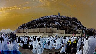
 Pilgrims atop the mountain during the
Hajj | |
| Highest point | |
| Elevation | 454 m (1,490 ft)
|
| Listing | Mountains of Saudi Arabia |
| Coordinates | 21°21′17″N 39°59′02″E / 21.35472°N 39.98389°E |
| Naming | |
| Native name | |
| Geography | |
 Mount Arafat Location of Mount Arafat within Saudi Arabia  Mount Arafat Mount Arafat (Middle East)  Mount Arafat Mount Arafat (Asia) | |
| Location | Near Mecca City, Makkah Province, the Hejaz Saudi Arabia |
| Parent range | Hijaz Mountains |
| Geology | |
| Age of rock | 9.13 ± 1.05 Mya |
| Mountain type | Grandiorite hill [1] |
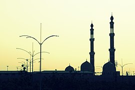
Mount Arafat ( Arabic: جَبَل عَرَفَات, romanized: Jabal ʿArafāt), and by its other Arabic name, Jabal ar-Raḥmah ( Arabic: جَبَل ٱلرَّحْمَة, lit. 'mountain of mercy'), [2] is a granodiorite hill [1] about 20 km (12 mi) southeast of Mecca, in the province of the same name in Saudi Arabia. [3] The mountain is approximately 70 m (230 ft) in height, with its highest point sitting at an elevation of 454 metres (1,490 ft).
According to Islamic traditions, the hill is the place where the Islamic prophet Muhammad stood and delivered the Farewell Sermon, also known as the Khutbat al-Wada', [4] to his companions (Sahabah) who had accompanied him for the Hajj towards the end of his life. Some Muslims also believe that Mount Arafat is the place where Adam and Eve ( Hawa) reunited on Earth after falling from Heaven, believing the mountain to be the place where they were forgiven, hence giving it the name Jabal ar-Rahmah, meaning "Mountain of Mercy". A pillar is erected on top of the mountain to show where this event is believed to have taken place.
The mountain is especially important during the Hajj, with the 9th day of the Islamic month of Dhu al-Hijjah, also known as the Day of 'Arafah after the mountain itself, being the day when Hajj pilgrims leave Mina for Arafat; this day is considered to be the most important day of the Hajj. The khutbah (sermon) is delivered and Zuhr and Asr prayers are prayed together in the valley. The pilgrims spend the whole day on the mountain invoking Allah to forgive their sins. [5]
Geology and radiology
A 2012 study classified Mount Arafat as a granodiorite rock which mainly consists of feldspar, quartz and muscovite, among other minerals. Using petrographic, fission track dating and γ-spectrometric (HPGe) techniques in order to study the geology, thermal history and the radiological hazards due to the presence of primordial radionuclides. [1]
The study yielded fission track age of 9.13 ± 1.05 Ma of the Mount Arafat granodiorite. In addition, the study reported that rifting, magmatism, volcanism and seafloor spreading that resulted in the formation of Red Sea seems to have altered the original age of the Arafat granodiorite under study to 9.13 ± 1.05 Ma. Measured radioactivity concentrations due to 226Ra, 232Th and 40K were found to not pose any radiological health hazard to the general public. [1]
Hajj
Arafat rituals end at sunset and pilgrims then move to Muzdalifah for Maghrib prayer and a shortened Isha prayer and for a short rest. [6]
The level area surrounding the hill is called the Plain of Arafat. The term Mount Arafat is sometimes applied to this entire area. It is an important place in Islam because, during the Hajj, pilgrims spend the afternoon there on the ninth day of Dhu al-Hijjah. Failure to be present in the plain of Arafat on the required day invalidates the pilgrimage. [7]
Since late 2010, this place is served by Mecca Metro. On a normal Hajj, it would be around 21 km (13 mi) to walk.[ citation needed]
-
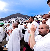
 Pilgrims supplicating
 -
-
 Pilgrims supplicating during Hajj
 -
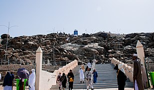 Entrance of Jabal ar-Rahmah (Mount of the Mercy)
 -
 Pilgrims
 -
-

-


.jpg)
_Mount_Arafat.jpg)
.jpg)


.jpg)
In literature
The hill is referenced in James Joyce's novel Finnegans Wake. [8]
See also
References
- ^ a b c d Qureshi, A. A.; Sultan, A.; Rashid, A.; Ali, M.; Waheed, A.; Manzoor, S.; Baloch, M. A.; Matiullah; Batool, S.; Khan, H. A. (September 2012). "Geological and radiological studies of the Mount Arafat, Mekkah, Saudi Arabia". Journal of Radioanalytical and Nuclear Chemistry. 293 (3): 955–963. doi: 10.1007/s10967-012-1776-0. ISSN 0236-5731. S2CID 95942060.
- ^ "Saudi Arabia Hajj: Millions at Mount Arafat for ceremonies". BBC News. 11 September 2016. Retrieved 2019-04-14.
- ^ "خرائط Google".
- ^ Burns, William E. (25 June 2010). Speeches in World History. Infobase Publishing. p. 79. ISBN 978-1-4381-2680-7. Retrieved 14 March 2024.
- ^ "More than 2 million pilgrims complete journey to Mount Arafat for second day of Hajj". Arab News. 2018-08-20. Retrieved 2019-04-14.
- ^ Peters, F.E., 1996. The Hajj: The Muslim pilgrimage to Mecca and the holy places. Princeton University Press.
- ^ Omar, W. (1952), "The Mecca Pilgrimage: Its Epidemiological Significance and Control", Postgraduate Medical Journal, 28 (319): 269–74, doi: 10.1136/pgmj.28.319.269, PMC 2530829, PMID 14929743
- ^ "Finnegans Wake". www.finwake.com. Retrieved 2016-07-18.
External links
-
 Media related to
Mount Arafat at Wikimedia Commons
Media related to
Mount Arafat at Wikimedia Commons - Muslim pilgrims gather at Mount Arafat for Hajj's key moment ( YouTube)
- Muslim pilgrims scale Mount Arafat for peak of hajj
- Millions Of Muslim Pilgrims Gather At Mount Arafat To Mark Pinnacle Of Hajj | TIME
- اكثر من 2 مليون حاج يصعدون إلى جبل عرفات 1433 هـ (in Arabic)
Hajj topics | ||
|---|---|---|
Every year, from the eighth to the twelfth day of
Dhu al-Hijjah. | ||
| Preparation |  | |
| Sequence | ||
| Mosques | ||
| Related | ||
Hills and
mountains on the Arabian Peninsula | |
|---|---|
Note: Mountains are sorted in alphabetical order, unless where it concerns ranges. The highest confirmed mountains in each country are indicated with 'HP', and those with the highest peak are indicated with 'HP', bearing in mind that in the UAE, the highest mountain and the mountain with the highest peak are different.
Outcrops are indicated with 'OC', and
outliers with 'OL', and
anticlines with 'AC'.
Volcanoes are indicated with 'V',
volcanic craters with 'VC',
lava fields with 'LF', and
volcanic fields with 'VF'.
Other notes:
|
.jpg)


| Saudi Arabia | 
 | |
|---|---|---|
| Iraq | ||
| Iran |
| |
| Syria | ||
| Lebanon | ||
| Palestine | ||
| International | |
|---|---|
| National | |